Explore Dubai from above using satellite imagery through our interactive satellite imagery portal, searched, tasked, and delivered by a team based right here in the UAE. View Downtown Dubai, Palm Jumeirah, Dubai Marina, Jebel Ali, and other parts of the emirate, pull historical satellite imagery from the archive, or task a brand-new capture. Satellite imagery isn't a live video feed; availability and acquisition dates depend on the satellite, the location, cloud cover, and archive coverage. Explore available imagery below, then request high-resolution satellite imagery for construction, mapping, infrastructure, environmental, and other professional applications, all with instant, transparent pricing.
Yes. Dubai can be viewed using satellite imagery through the interactive satellite imagery portal on this page. Available imagery may be a recent capture or an older archive image, depending on the location, satellite, and archive availability. Satellite imagery isn't a live video feed; each image represents a specific satellite pass over Dubai, not continuous footage.
Satellite View of Dubai
Explore the satellite view of Dubai using the interactive satellite imagery portal below. The portal lets you pan and zoom across the emirate and investigate locations including Downtown Dubai, Palm Jumeirah, Dubai Marina, Jebel Ali, Dubai Creek, and the rest of Dubai's districts. Use the map to explore an area, then check what archive and new-tasking imagery is available for it, with an instant price estimate before you commit to anything.
Opening imagery workspace…
Satellite Map of Dubai: How to Use This Tool
The map above is a working satellite map of Dubai, not just a viewer: you can search any location, check what imagery dates are available, and request archive or newly tasked imagery for it, all in the same workspace. Use it to view and analyze the latest and historical satellite images of Dubai in a few steps:
Search or pan to your exact area within Dubai using the map's location search bar.
Draw a rectangle or polygon over your area of interest, or upload a boundary file (KML, KMZ, or zipped Shapefile).
Choose your capture mode, archive imagery for an instant search of existing captures, or new tasking for a fresh satellite pass, and set your preferred resolution, date range, and maximum cloud cover.
Review the available scenes for your area, along with an instant, transparent price estimate, so you know your high-resolution satellite image cost before you commit.
Submit your request to download archive imagery or order new tasking. Our Dubai-based team confirms details, sends you a price quote, and delivers your imagery.
Sample Satellite Images of Dubai: Burj Khalifa, Burj Al Arab, Palm Jumeirah, World Island, and Jebel Ali
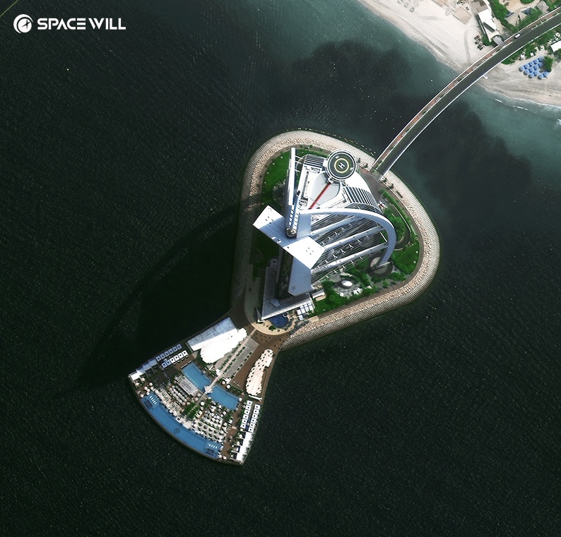
High-resolution satellite view of the Burj Khalifa and Downtown Dubai, showing the tower, Burj Park, and the Dubai Fountain in sub-meter detailSuperView Neo satellite imagery of the Burj Al Arab, Dubai, UAE, resolving the sail-shaped hotel and its artificial island in sub-meter detail
Satellite: SuperView Neo · Resolution: Sub-meter
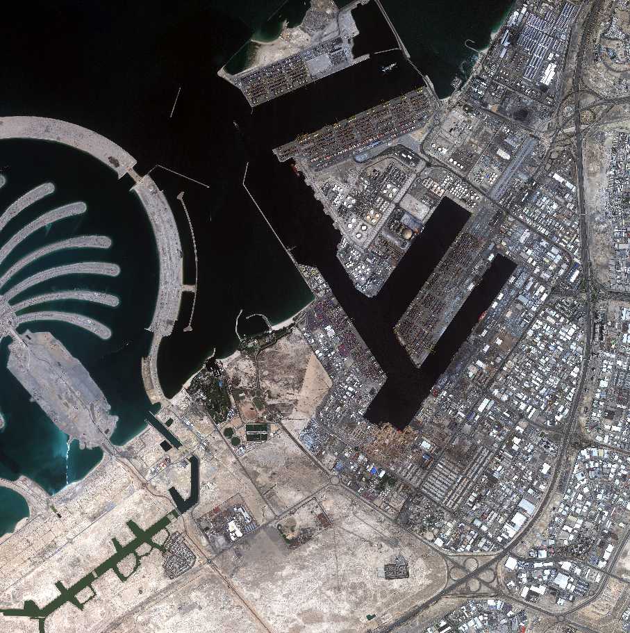
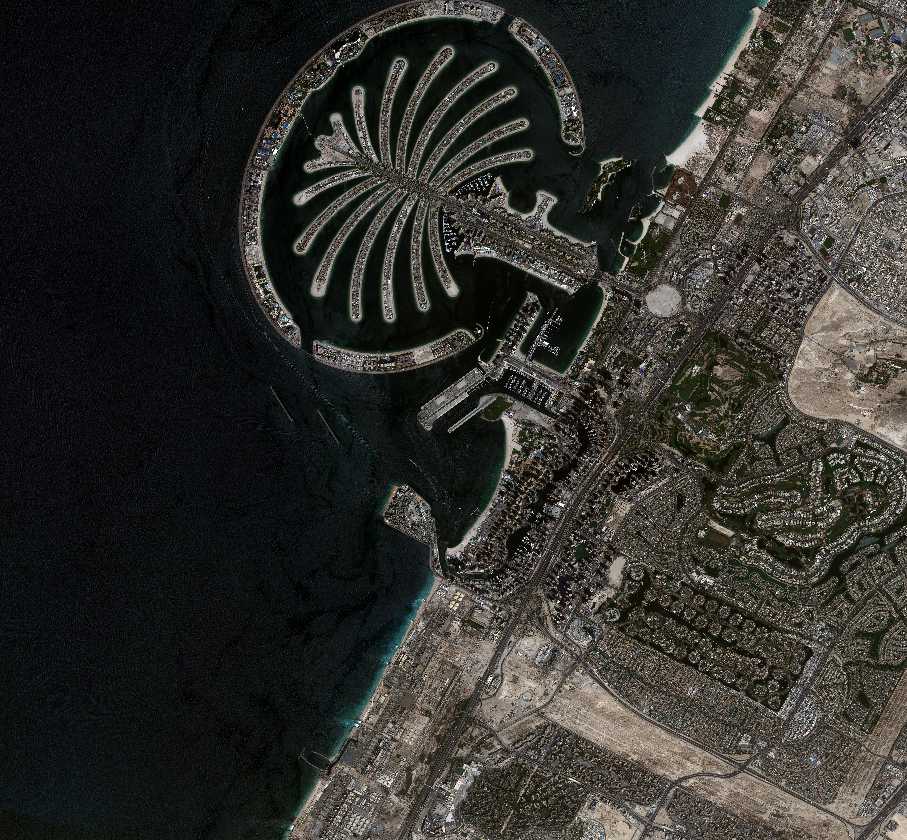
BJ3N (Beijing-3B) multispectral satellite imagery of Palm Jumeirah and Jebel Ali Port, Dubai, UAE, 1.2m resolution, captured March 14, 2026
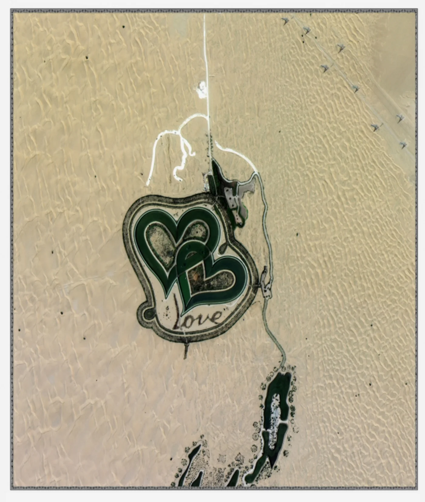
A fused (pan-sharpened) satellite image of Love Lake, the heart-shaped lake in the Al Qudra desert outside Dubai, captured August 31, 2020. Imagery courtesy of the China Academy of Space Technology (CAST).
Captured: August 31, 2020
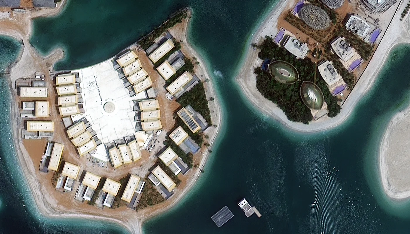
SuperView Neo-1 satellite imagery at 30cm natural-color resolution over a villa development on Dubai's World Island archipelago, captured August 12, 2022.
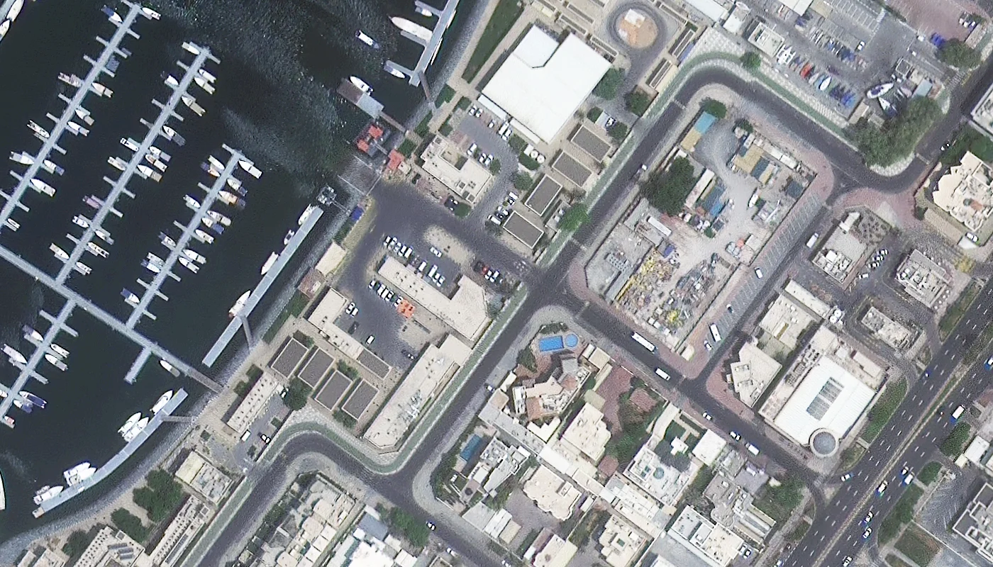
SuperView Neo-1 satellite imagery at 30cm natural-color resolution over a Dubai marina and waterfront district, individual yachts and buildings clearly resolved, captured August 12, 2022.
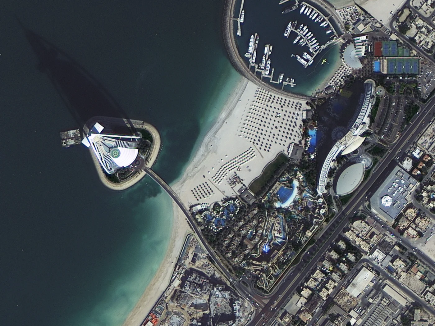
TripleSat satellite imagery at 1m natural-color resolution over the Burj Al Arab and Jumeirah Beach, captured October 31, 2015.
Captured: October 31, 2015 · Satellite: TripleSat · Resolution: 1m
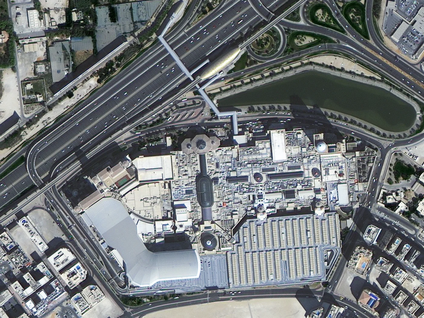
TripleSat satellite imagery at 1m natural-color resolution over The Dubai Mall and the surrounding Sheikh Zayed Road interchange, captured October 31, 2015.
Captured: October 31, 2015 · Satellite: TripleSat · Resolution: 1m
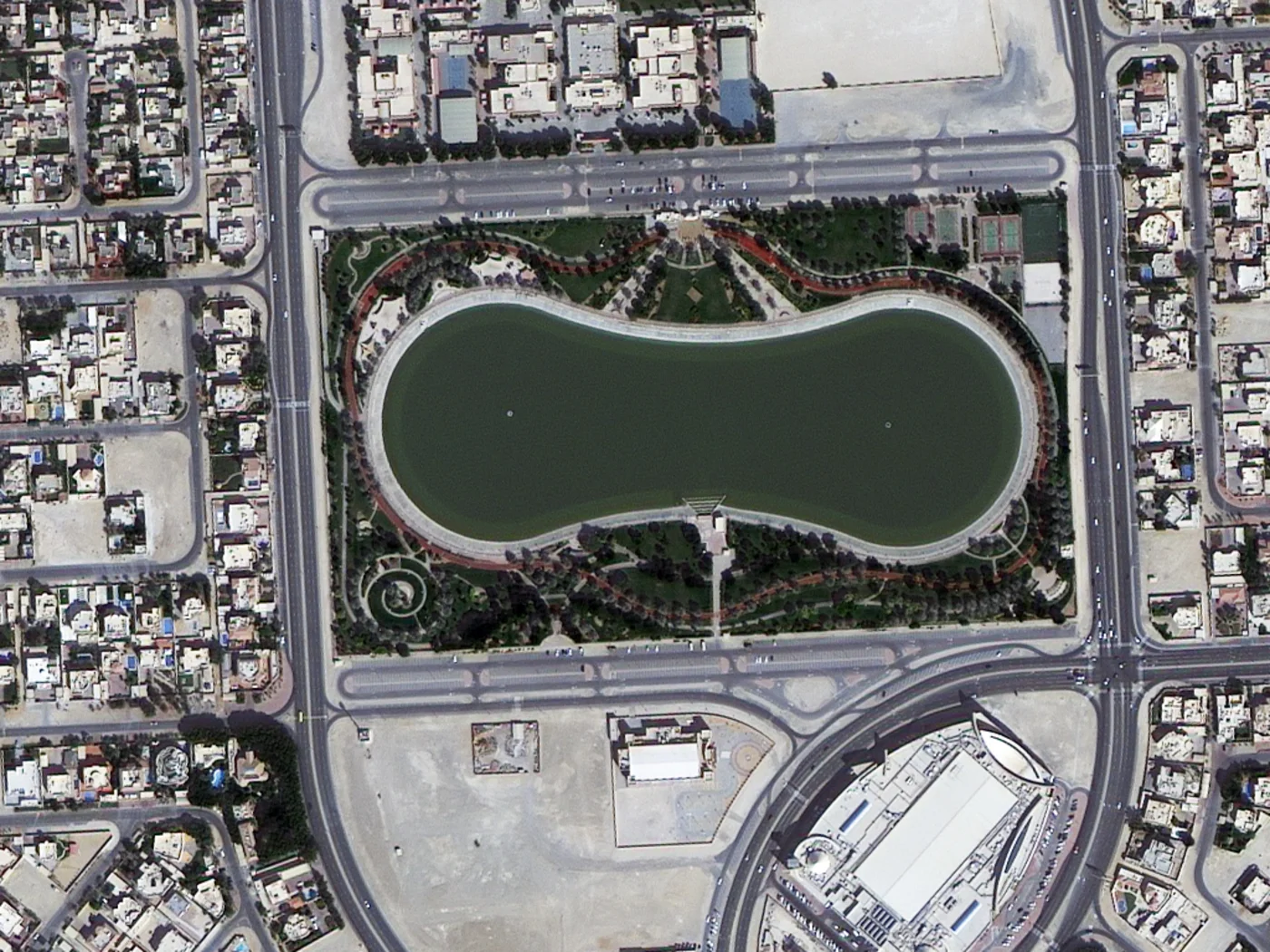
TripleSat satellite imagery at 1m natural-color resolution over a landscaped park and lake in central Dubai, captured October 31, 2015.
Captured: October 31, 2015 · Satellite: TripleSat · Resolution: 1m
Satellite Imagery Coverage Across Dubai and the UAE
High-resolution satellite images and maps of Dubai are available from multiple commercial constellations and free public archives, so coverage isn't limited to a single sensor or a single date. Our satellite imagery coverage extends across every district of Dubai, from Downtown Dubai, Business Bay, and Dubai Marina to Jumeirah, Deira, Bur Dubai, Al Quoz, Dubai Silicon Oasis, Dubai Investment Park, Dubai South, and Jebel Ali. Coverage continues beyond the city itself across the wider UAE, including Abu Dhabi, Sharjah, and the northern emirates. Because our team is based in Dubai, we know the local geography, the fastest routes to a price quote, and how to get you a personalized answer, not a generic one. Whether your area of interest is a single building, an entire industrial zone, or the full coastline of the UAE, the same search and tasking tools on this page work across the whole country.
What You Can See in Dubai Satellite Imagery
A satellite view of Dubai captures one of the fastest-built cities on Earth. What was a small fishing and pearling village a century ago is now a dense skyline visible clearly from orbit. A few landmarks that show up distinctly in high-resolution satellite photos of Dubai:
Burj Khalifa, the world's tallest building, standing out in Downtown Dubai next to Burj Park and the Dubai Fountain, shown in the sample satellite image above
The Dubai Mall, one of the largest retail complexes in the world, sitting just beside the Burj Khalifa
Burj Al Arab, the sail-shaped luxury hotel built on its own artificial island off Jumeirah Beach, clearly resolved in sub-meter satellite imagery, shown in the sample gallery above
Palm Jumeirah, the palm-shaped artificial island that's instantly recognizable in any satellite view of Dubai, shown in the sample imagery above
Jebel Ali Port, one of the busiest man-made harbors in the world, visible along the southwestern coastline
Dubai Creek, the natural inlet running through the older parts of the city, separating Deira from Bur Dubai
Dubai Marina, a dense waterfront district of high-rise towers built around an artificial canal
Museum of the Future and the Dubai Frame, two of the city's most distinctive modern landmarks near Downtown
Expo City Dubai, the large-scale development site south of the city, visible for its distinctive pavilion layout
Applications of Satellite Imagery in Dubai
Satellite imagery of Dubai supports a wide range of work across the emirate's fast-changing landscape, from tracking a single construction site to planning infrastructure across large, multi-site projects:
Urban planning and development tracking, monitoring how quickly new districts and towers rise across the city
Construction progress monitoring, tracking major projects from groundbreaking to completion without site visits
Real estate and property assessment, verifying land condition, surrounding development, and site access before acquisition
Infrastructure and transport planning, mapping road networks, metro expansion, and utility corridors across the emirate
Mining and quarry monitoring, measuring extraction volumes and tracking site expansion across inland mining operations in the UAE
Oil and gas infrastructure monitoring, keeping watch over pipelines, storage terminals, and offshore facilities without dispatching a crew
Solar and renewable energy site planning, assessing rooftop and ground-mount solar potential across commercial and residential areas
Water resource and utility network mapping, supporting planning around desalination, irrigation, and municipal water infrastructure
Retail and hospitality site selection, evaluating foot traffic patterns and surrounding development before choosing a location
Disaster management and emergency response, giving responders fast situational awareness after flooding, storms, or other emergencies
Benefits of Satellite Imagery for Dubai Businesses
For companies operating in or around Dubai, satellite imagery of Dubai is a faster, cheaper, and more accurate way to verify conditions on the ground, backed by a Dubai-based team that treats every request as its own project, not a ticket in a queue:
Lower cost than site visits, replacing repeat travel, drone mobilization, or third-party surveys with a single image or an ongoing monitoring plan
Faster turnaround and faster decisions, with archive imagery delivered instantly and new tasking available in days, so due diligence and go/no-go calls happen sooner
Higher accuracy for large-scale projects, with sub-meter resolution imagery precise enough for measurement, mapping, and analysis across multi-site or multi-phase developments
AI-powered data analysis, with imagery structured for change detection, object detection, and automated monitoring pipelines rather than manual review alone
Remote monitoring at scale of assets, construction sites, or supply chain and energy infrastructure across the city and the wider UAE
Historical comparison, using archive imagery to show how a site or area has changed over months or years
Independent, defensible verification of site conditions for insurance, financing, or regulatory purposes
Personalized local service, with a Dubai-based team that understands local geography, regulations, and turnaround expectations better than an offshore provider
Satellite Constellations Covering Dubai
Satellite imagery of Dubai comes from a mix of high-resolution commercial constellations and free public archives, so you can choose based on resolution, cost, and how recent the capture needs to be:
21AT (Twenty First Century Aerospace Technology), a Singapore-based operator whose TripleSat Constellation flies three satellites in the same sun-synchronous orbit, offset by 33 minutes from one another for frequent revisits over Dubai. 21AT also operates the BJ-3 (Beijing-3) pair, BJ-3A launched June 11, 2021, and BJ-3B launched August 24, 2022, capturing optical imagery down to 30cm panchromatic and 1.2m multispectral resolution
SuperView Neo, a commercial constellation delivering 25cm to 50cm resolution optical imagery, well suited to resolving individual buildings, vehicles, and construction equipment across Dubai
Gaofen satellites, part of China's high-resolution civilian Earth observation program, contributing sub-meter to multi-meter resolution archive coverage over the UAE
Landsat, a free, continuous 30m resolution multispectral archive going back decades, useful for tracking Dubai's urban growth over time
Sentinel-2, ESA's free 10m multispectral archive, useful for broader regional monitoring and change detection around Dubai
How Satellite Imagery Resolution and Cost Work for Dubai
Not every project needs the same level of detail, and high-resolution satellite images of Dubai are priced according to the resolution, area, and tasking mode you choose. Free archive imagery from Sentinel-2 (10m) and Landsat (30m) costs nothing and is useful for broad land-cover monitoring, regional change detection, and long-term comparisons, though individual buildings and vehicles won't be distinguishable at these resolutions. Commercial imagery from constellations like 21AT and SuperView Neo brings that down to sub-meter detail, 25cm to 50cm, sharp enough to identify individual structures, vehicles, and construction equipment, at a cost that scales with area size and resolution rather than a flat fee. For most business use cases in Dubai, urban planning, construction monitoring, mining, oil and gas, and property assessment, sub-meter resolution is the practical choice, while free archive data works well for broader environmental and land-cover questions. Every search on this page returns an instant, transparent price estimate before you commit, so there are no surprises on cost.
Satellite Imagery Resolutions Available for Dubai
Resolution
Source
Best For
25cm–50cm panchromatic
21AT / SuperView Neo (commercial)
Individual buildings, vehicles, and construction equipment
1.2m multispectral
21AT BJ-3 (Beijing-3) constellation (commercial)
Detailed site analysis with color/spectral data
Sub-meter to multi-meter
Gaofen satellites (archive)
Regional and national-scale mapping over the UAE
10m multispectral
Sentinel-2 (free)
Regional monitoring and change detection
30m multispectral
Landsat (free)
Long-term tracking of Dubai's urban growth
Free vs. Commercial Satellite Imagery of Dubai
Type
Typical Resolution
Best For
Free/public imagery (Sentinel-2, Landsat)
10m–30m
Regional monitoring, environmental analysis, general land-cover mapping
Commercial imagery (21AT, SuperView Neo)
25cm–1.2m
Buildings, construction, infrastructure, and detailed site analysis
Frequently Asked Questions
What is a satellite view of Dubai?
A satellite view of Dubai is an overhead image of the emirate captured by an Earth-observation satellite. Depending on the sensor, it can show Dubai's buildings, roads, coastline, ports, and construction sites at resolutions ranging from 30m regional detail down to 25cm sub-meter detail.
Can I see a live satellite view of Dubai?
Satellite imagery isn't updated in true real-time the way a live traffic camera is, but Dubai is imaged frequently by multiple satellite constellations, in some cases daily, so recent, near-current imagery is available for most areas of the city.
What is the most recent satellite imagery available for Dubai?
Recent tasking imagery is available on request, typically within a few days depending on cloud cover and satellite revisit schedules. Archive imagery covering Dubai extends back several years across multiple sensors.
Can I download a satellite image of Dubai?
Yes. Archive satellite imagery of Dubai can be searched and purchased directly through the map on this page, with an instant price estimate shown before you order. Newly tasked imagery is delivered once the capture and processing are complete.
How much do high-resolution satellite images of Dubai cost?
Cost depends on the resolution, area size, and whether you choose archive imagery or new tasking. Free archive options like Sentinel-2 and Landsat cost nothing; commercial sub-meter imagery is priced by area and resolution. Every search on this page returns an instant, transparent price estimate before you order.
Can I see the Burj Khalifa from satellite imagery?
Yes. High-resolution satellite imagery of Dubai, from sensors like SuperView Neo and 21AT's constellations, resolves the Burj Khalifa and Downtown Dubai clearly enough to distinguish individual buildings, roads, and even vehicles, as shown in the sample satellite image of Burj Khalifa in the gallery on this page.
Can I see Jebel Ali Port from satellite view?
Yes. Jebel Ali Port, on Dubai's southwestern coast, is one of the most frequently imaged commercial ports in the region and shows clearly in both archive and new tasking imagery, as seen in the sample gallery on this page.
What resolution is available for Dubai satellite imagery?
Resolution ranges from 10m (Sentinel-2) and 30m (Landsat) free archive imagery up to sub-meter commercial imagery from 21AT and SuperView Neo constellations, down to 25-50cm panchromatic and 1.2m multispectral depending on the sensor and tasking mode selected.
Does coverage include all of Dubai, or just the downtown area?
Coverage extends across every district of Dubai and the wider UAE, not just central landmarks. The same search and tasking tools on this page work for any area of interest across the country.
What areas of Dubai does satellite coverage include?
Coverage spans every district of Dubai, from Downtown Dubai and Dubai Marina to Jebel Ali, Dubai South, and Dubai Silicon Oasis, as well as the wider UAE including Abu Dhabi and Sharjah.
Can satellite imagery track construction progress in Dubai?
Yes. Comparing satellite imagery captured at different dates over the same site is a common way to monitor construction progress remotely, from groundbreaking through completion, without needing repeated site visits.
Can satellite imagery support mining or oil and gas monitoring in the UAE?
Yes. Satellite imagery is used to track extraction volumes and site expansion at mining and quarry operations, and to monitor pipelines, storage terminals, and offshore infrastructure for oil and gas operators, often with AI-assisted change detection between capture dates.
What is the difference between free and commercial satellite imagery of Dubai?
Free imagery from Sentinel-2 and Landsat offers 10m and 30m resolution, suited to broad land-cover and environmental monitoring, at no cost. Commercial imagery from constellations like 21AT and SuperView Neo offers sub-meter resolution, 25cm to 50cm, suited to identifying individual buildings, vehicles, and fine infrastructure detail, priced by area and resolution.
Is this a local Dubai-based provider?
Yes. Our team is based in Dubai, which means faster response times, local knowledge of the emirate's geography and regulations, and a more personalized service than an offshore provider can offer.