

Precision Agriculture With Satellite Imagery
On this page
- What is precision agriculture with satellite imagery?
- Why precision agriculture depends on satellite data
- The satellite fleet behind the data
- See problems before they are visible on the ground
- 01. Time-series crop vigor monitoring with NDVI
- 02. Early pest and disease detection via the Red Edge band
- 03. Soil moisture mapping and smart irrigation scheduling
- Turn imagery into a season plan, not just a snapshot
- 04. Multi-decade trend analysis and smart-zone delineation
- 05. Variable-rate seeding and fertilizer prescription maps
- 06. AI-driven yield forecasting
- Close the gap between seeing a problem and fixing it
- 07. On-demand, in-orbit AI analysis
- 08. All-weather monitoring with radar (SAR)
- 09. Automated crop classification and land-use change detection
- Turn imagery into evidence, not just insight
- 10. Weather and natural-disaster early warning
- 11. Insurance claims and subsidy validation
- 12. Full-cycle documentation with a multi-year archive
- Vegetation index library
- SAVI (Soil-Adjusted Vegetation Index)
- GNDVI (Green NDVI)
- EVI (Enhanced Vegetation Index)
- Case studies for satellite farming in production
- China's wheat belt and regional yield forecasting
- Henan Province daily soil-moisture monitoring
- Satellite vs. drone vs. ground scouting
- Frequently asked questions
- Sources and further reading
Precision agriculture is the practice of managing a field at the sub-field level instead of treating it as one uniform block, and satellite imagery is what makes that practice possible at scale. In 2026, commercial constellations resolve farmland down to 25 cm with daily revisit and onboard AI, while free ESA and NASA/USGS data still anchor multi-decade trend analysis. Together, these sources deliver daily, weekly, or monthly field updates on crop health and soil moisture information, feeding the vegetation-index maps, yield models, and variable-rate prescriptions that a precision-agriculture program actually runs on. What follows is the fuller picture, how satellite data becomes a precision-agriculture decision in 2026, what has changed, and what it can do for a field this season. If you're looking for the imagery and monitoring service itself rather than the background on how it works, see our agriculture satellite imagery page.
Quick answer
Precision agriculture with satellite imagery turns orbital sensor data, including optical, multispectral, thermal, and radar, into field-level intelligence such as crop-vigor and growth-pattern maps, yield forecasts, soil-moisture readings, and pest-risk detection and response alerts, generated without a site visit. Coverage can be tasked daily, weekly, or monthly depending on the source, and modern constellations resolve as fine as 25 cm with daily revisit and onboard AI, so growers can act on a field problem within hours instead of the one to two weeks a manual scouting rotation typically takes.
What is precision agriculture with satellite imagery?
Precision agriculture is a way of managing a field zone by zone, seeding, watering, and fertilizing each part according to what it actually needs instead of applying one blanket rate across the whole field. Satellite imagery is what makes that practical at scale, imagery captured from orbit and processed into a form farmers, agronomists, insurers, and governments can actually act on, whether that's a vegetation-health map, a soil-moisture reading, a yield forecast, or a boundary record, rather than a raw photograph. It works by measuring how much light a crop canopy reflects across different wavelengths, visible, near-infrared, short-wave infrared, and, for radar sensors, microwave, since a healthy, well-watered plant reflects light very differently than a stressed, diseased, or drought-hit one. Software then converts those reflectance values into vegetation indices like NDVI, which turn a satellite pass into a color-coded map anyone can read at a glance, no remote-sensing background required.
Three kinds of sensors do this work, optical satellites (the most common, capturing visible and near-infrared light, but blind through cloud cover), thermal sensors (measuring canopy temperature to flag water stress), and radar, or SAR, satellites (which generate their own signal and see through cloud, rain, and darkness). Most serious precision-agriculture programs combine at least two of the three, since no single sensor type covers every growing condition on its own.
Why precision agriculture depends on satellite data
Global precision-agriculture spend passed an estimated $13 billion in 2026, and industry trackers now put satellite-based monitoring adoption above 65 to 70% among large-scale farms worldwide, up sharply from a decade ago when the technology was mostly a pilot-project curiosity. Two things changed, the sensors and the economics.
On the sensor side, new commercial constellations resolve agricultural fields at 25 cm, some run AI models in orbit to flag anomalies before the image even reaches the ground, and radar satellites now deliver near-daily, cloud-proof soil-moisture readings that were not practical a few seasons ago. On the economics side, rising input costs such as fertilizer, water, diesel, and labor, combined with climate volatility including longer droughts and sharper hail and flood events, have made treating a whole field the same way the expensive option. Managing inputs at the sub-field level with orbital imagery, what most people now call satellite farming, has become the cheaper choice rather than the premium one.
The satellite fleet behind the data
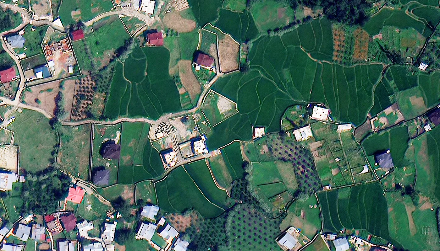
Satellite imagery is not one data source. It is a mix of commercial very-high-resolution optical satellites, open-access government constellations, and radar systems, and each is suited to a different agricultural task. The table below covers the sensors most relevant to farm monitoring in 2026.
| Satellite / constellation | Sensor | Native resolution | Key bands / swath | Revisit and notes |
|---|---|---|---|---|
| SuperView Neo-1 (03/04) | Optical | 25 cm PAN, 1 m MS | RGB + NIR | Daily-cadence revisit |
| SuperView Neo-3 | Optical | 50 cm PAN, 2 m MS | 8-band MS, 130 km swath | Regional vegetation mapping |
| TripleSat Constellation | Optical | 80 cm PAN, 3.2 m MS | RGB + NIR | Three-satellite array, near-daily |
| Beijing-3A | Optical | 50 cm PAN, 2 m MS | PAN + 4-band MS, 23.5 km swath | Mono, stereo and tri-stereo |
| BJ3N (Beijing-3B) | Optical, onboard AI | 30 cm PAN, 1.2 m MS | PAN + 4-band (RGBN) | In-orbit AI analytics |
| Beijing-1 (21AT) | Optical | 4 m MS | Wide-area optical | Deep historical archive |
| Sentinel-1 (ESA) | Radar (SAR) | 5 to 20 m | C-Band, active microwave | Open-access, sees through cloud and dark |
| Sentinel-2 (ESA) | Optical | 10 to 60 m MS | 13 bands (4 at 10 m, 6 at 20 m, 3 at 60 m) incl. Red Edge | Open-access, 3 to 5 day revisit |
| Landsat 4 / 5 / 7 / 8 / 9 | Optical, Thermal | 15 to 30 m | OLI-2 / TIRS-2 thermal | Archive back to 1982, 8 to 16 day revisit |
The pattern here is deliberate. Commercial optical satellites such as SuperView Neo, TripleSat, and the Beijing-3 series supply the fine detail and fast revisit that in-season decisions need, while the free ESA and NASA/USGS constellations supply the multi-decade archive and consistent global coverage that historical baselining needs. Radar fills the gap both leave open, giving a clear look at the ground even when clouds will not cooperate. Elsewhere in the industry, platforms built around Planet Labs' PlanetScope constellation follow a similar logic at 3 m resolution with daily revisit for crop tracking and pest-risk detection and response, which is worth knowing about when comparing agriculture satellite imagery providers, even outside the specific fleet covered here. Across the industry, cadence generally falls into three tiers, daily tasking for active-season decisions, weekly passes such as Sentinel-2's 3 to 5 day cycle for routine monitoring, and monthly-equivalent baselining from long-archive sources like Landsat for trend and soil-health tracking.
See problems before they are visible on the ground
The core promise of satellite farming is simple, catching stress signals in a plant's spectral signature days or even weeks before they show up as a color change a human eye could spot from the field edge.
01. Time-series crop vigor monitoring with NDVI
The Normalized Difference Vegetation Index compares how much red and near-infrared light a crop canopy reflects. Healthy, dense vegetation absorbs red light for photosynthesis and reflects NIR strongly, which produces a high NDVI value, while stressed or sparse canopy does the opposite. Because NDVI can be generated from nearly every optical satellite in the fleet, including SuperView Neo, TripleSat, Sentinel-2, and Landsat, it remains the fastest way to get a field-wide health map in any given week of the season.
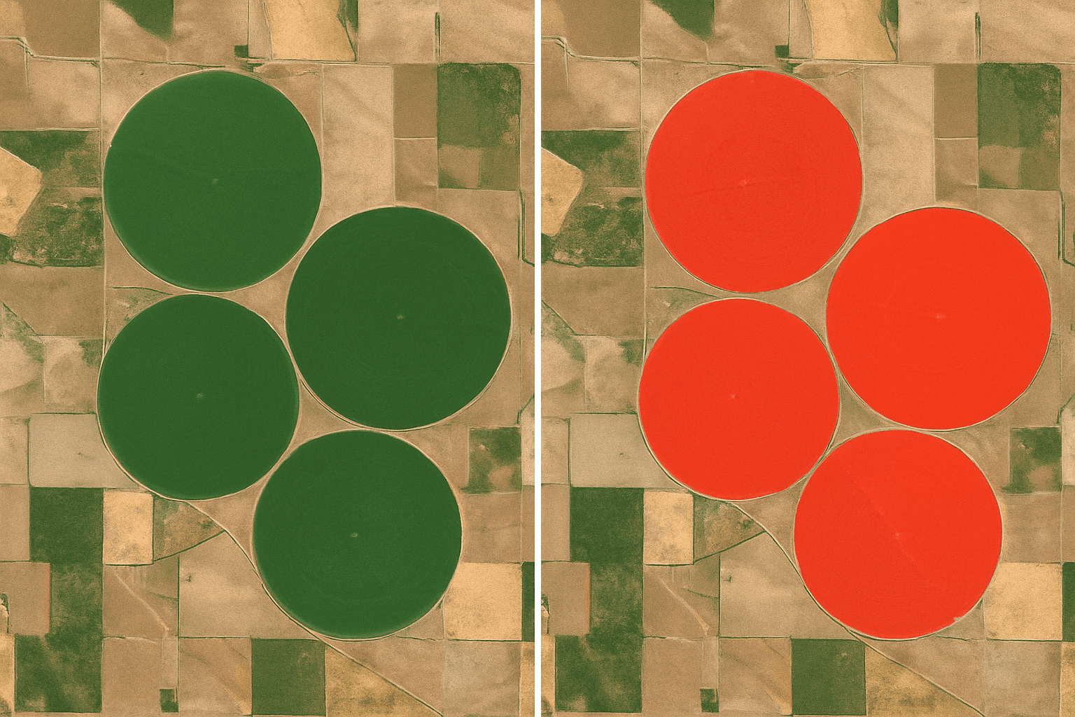
NDVI = (NIR minus Red) divided by (NIR plus Red), sourced from SuperView Neo-1, TripleSat, Sentinel-2, and Landsat 8/9
02. Early pest and disease detection via the Red Edge band
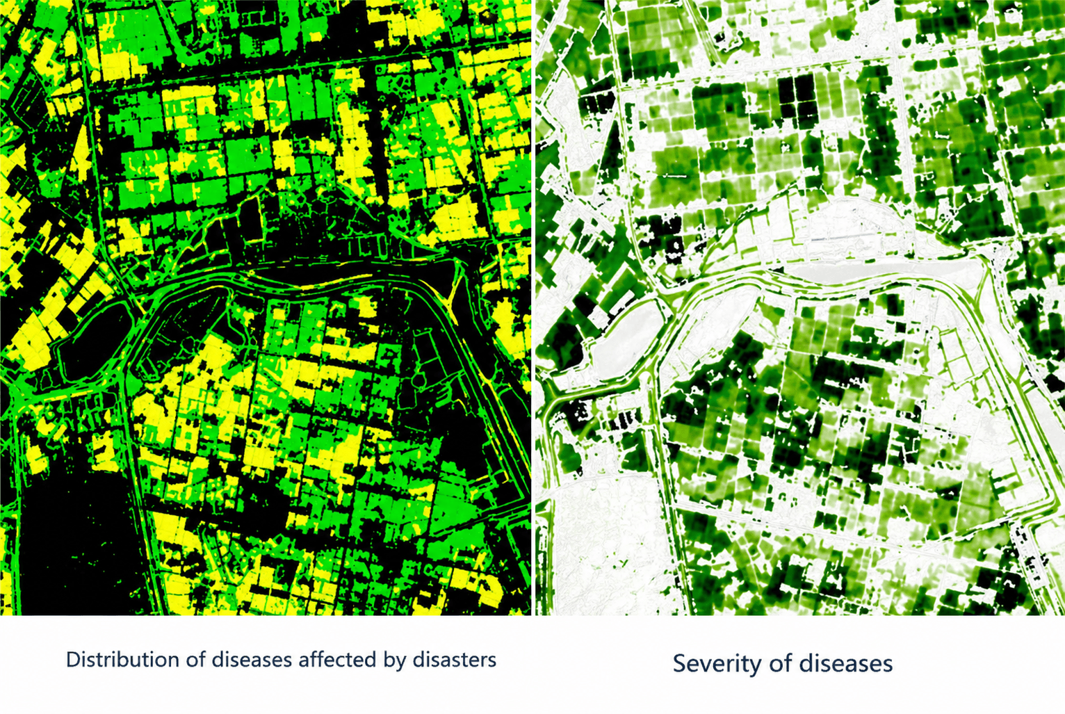
Pests and fungal disease damage chlorophyll and internal leaf structure before a plant shows any visible surface discoloration. The Red Edge band, between 690 and 770 nm, is carried by Sentinel-2, GF-6, and Superview-2's 1+8 band sensor, and it is tuned to exactly that transition zone in the light spectrum. That is why NDRE, the Normalized Difference Red Edge index, can flag nutrient deficiency, nitrogen stress, and early infestation days before a standard NDVI map would show anything unusual. For the full breakdown of which pathogen causes which symptom, see our guide to crop disease types, symptoms, and control.
03. Soil moisture mapping and smart irrigation scheduling

Three sensor types work together here. Sentinel-1 and commercial L-band SAR penetrate cloud cover to map surface soil roughness and moisture on a near-daily basis, which matters most in wet-season regions where optical satellites sit blind for weeks at a time. Separately, the thermal band on Landsat 8 and 9 (TIRS-2) measures canopy temperature to calculate the Crop Water Stress Index, flagging exactly which zones are dehydrating before yield loss sets in. A third option, NDMI (Normalized Difference Moisture Index), uses the near-infrared and short-wave infrared bands, (NIR minus SWIR) divided by (NIR plus SWIR), to read water content inside the plant canopy itself rather than the soil surface or its temperature, which is why agronomists often run NDMI alongside NDVI specifically to separate a genuine water-stress signal from a nutrient or pest problem that looks similar on a standard vigor map. Paired with elevation data that maps natural drainage, this combination answers both how wet the soil and canopy are and where the water actually needs to go. For a deeper dive on this specific piece, including the satellite fleet, indices, and a daily-mapping case study, see our guide to satellite imagery for irrigation and soil moisture monitoring.
Turn imagery into a season plan, not just a snapshot
A single image only shows today's status. A time series, sometimes decades long, shows where to invest, where to cut inputs, and what to expect at harvest.
04. Multi-decade trend analysis and smart-zone delineation
Landsat's archive stretches back to Landsat 4 in 1982, with Landsat 5 alone operating for nearly 30 years and Landsat 7 online since 1999. That depth lets agronomists build long-term soil-productivity baselines and map degradation trends that a single season of data simply cannot show. Overlaying that historical record with a high-resolution commercial archive, such as Beijing-1 or TripleSat, lets farms divide large tracts into permanent, productivity-based management zones instead of treating a field as one uniform unit.
Reading that archive well follows a consistent pattern regardless of which index is used. First, place the current image in the plant's actual growth stage, since a low NDVI reading means something different at emergence than at peak canopy; second, compare that reading against the field's own historical trend line to see whether it is a real anomaly or normal season-to-season variation; third, pick the specific index that matches the suspected cause, NDMI for water, GNDVI for nitrogen, SAVI for early-season sparse canopy; and fourth, cross-reference two or more indices together, since low vigor paired with low moisture points somewhere very different than low vigor paired with normal moisture.
05. Variable-rate seeding and fertilizer prescription maps
High-resolution multispectral data, such as 50 cm imagery from Beijing-3A, imports directly into GIS software to build prescription maps for variable-rate seeding and fertilization. Growers apply fewer seeds and less input in historically low-performing zones, and full rate where the data shows the field can support it. This is the step that turns a vegetation-index map from a diagnostic tool into an actual machine-control file.
06. AI-driven yield forecasting

Modern yield models blend machine learning with biophysical phenological modeling, not spectral data alone, to forecast harvest outcomes and estimate yields with roughly 85% accuracy at the county level. Superview Neo-3's 130 km swath at 50 cm and 2 m resolution makes this practical at scale, since an entire province can be monitored in a single pass without losing the sub-meter detail needed to track localized crop development. Meanwhile, open Sentinel-2 and Landsat data fill in continuous biomass tracking from seeding through maturity. For the full breakdown of how these yield models work, the data and satellites behind them, and how accurate they actually are, see our guide to satellite imagery for agricultural yield estimation.
Close the gap between seeing a problem and fixing it
Detail only helps if it arrives in time to act on. This is where onboard AI and all-weather radar change the math.
07. On-demand, in-orbit AI analysis
Downloading and processing 30 cm imagery on the ground used to delay critical interventions by days. BJ3N (Beijing-3B) changes that by running AI models onboard the satellite itself, identifying features and completing initial analytics before the image is even downlinked. Once it lands, cloud delivery platforms can turn a tasked acquisition into a finished agricultural map in as little as 1 to 1.5 hours, fast enough to inform a spray decision the same day.
08. All-weather monitoring with radar (SAR)
Persistent cloud cover during wet seasons routinely blinds optical satellites for weeks at a stretch. Sentinel-1's C-band SAR and commercial L-band radar constellations solve this by transmitting their own microwave pulses instead of relying on reflected sunlight, so they can image the ground through cloud, rain, or full darkness. For monsoon and tropical growing regions, SAR is often the only imagery available for a large share of the season, not simply an optional extra layer.
09. Automated crop classification and land-use change detection
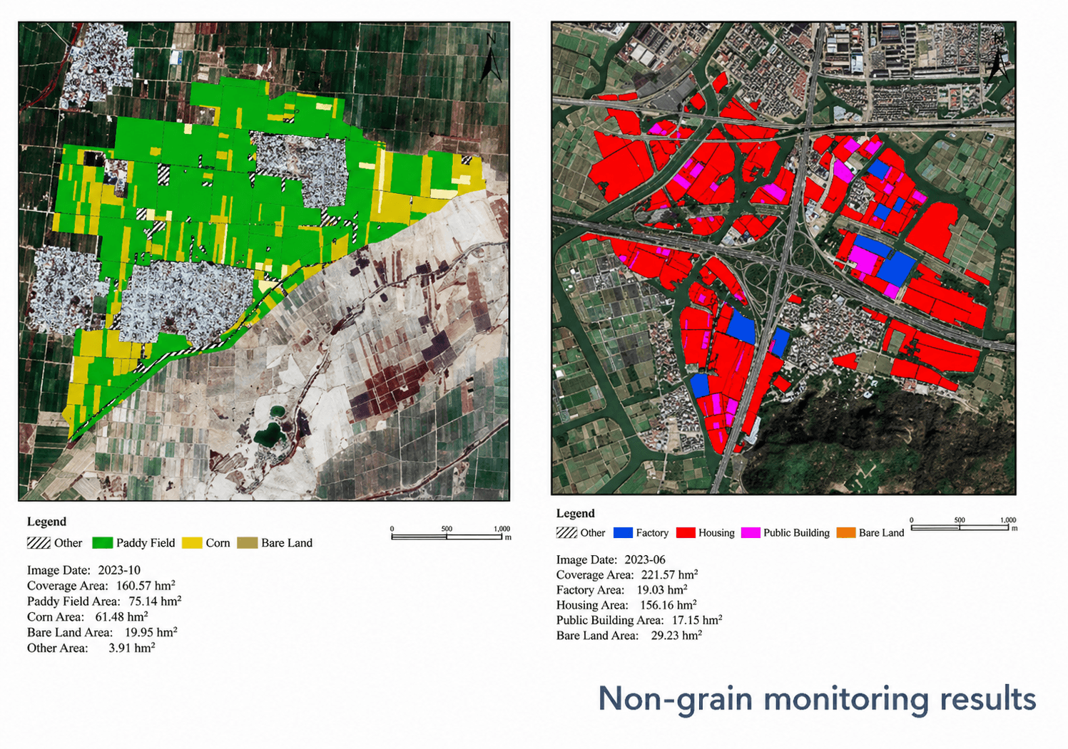
Deep-learning models trained on multispectral archives now classify crop type and flag non-grain land-use changes, such as an unauthorized greenhouse, an illegally drained pond, or encroachment onto protected farmland, with better than 90% accuracy. Run across a region rather than a single farm, this is the same capability governments use for subsidy and compliance monitoring, covered in more detail below.
Turn imagery into evidence, not just insight
Beyond day-to-day management, a persistent satellite record becomes documentation for weather risk, insurers, regulators, and buyers alike.
10. Weather and natural-disaster early warning
Combining farm satellite data with weather monitoring gives an early read on drought onset, flood risk, and storm tracks well before ground conditions confirm it. That gives growers a window to adjust irrigation, harvest timing, or protective measures before an event rather than after.
11. Insurance claims and subsidy validation
After a hail or flood event, insurers increasingly compare pre- and post-event NDVI instead of scheduling an on-site adjuster for every affected field, which lets them remotely distinguish total loss from partial damage and generate claim documentation in a fraction of the time a manual inspection round takes. Governments run the same before-and-after comparison at regional scale to validate drought and flood impact for agricultural subsidy programs. Archive imagery also lets both sides verify field boundaries and land-use history against years of prior acquisitions rather than paper records that may be out of date.

12. Full-cycle documentation with a multi-year archive
Every acquisition adds to a running record of a field's productivity, boundary history, and land condition. That archive is what turns satellite imagery from a monitoring tool into a defensible paper trail for land-value assessments, lease negotiations, sustainability reporting, and regulatory audits that ask for evidence, not just a current snapshot.
Vegetation index library
NDVI and NDRE cover most day-to-day monitoring, but the wider index library, built from NIR, Red Edge, Yellow, and thermal bands across the fleet above, answers more specific agronomic questions on demand.
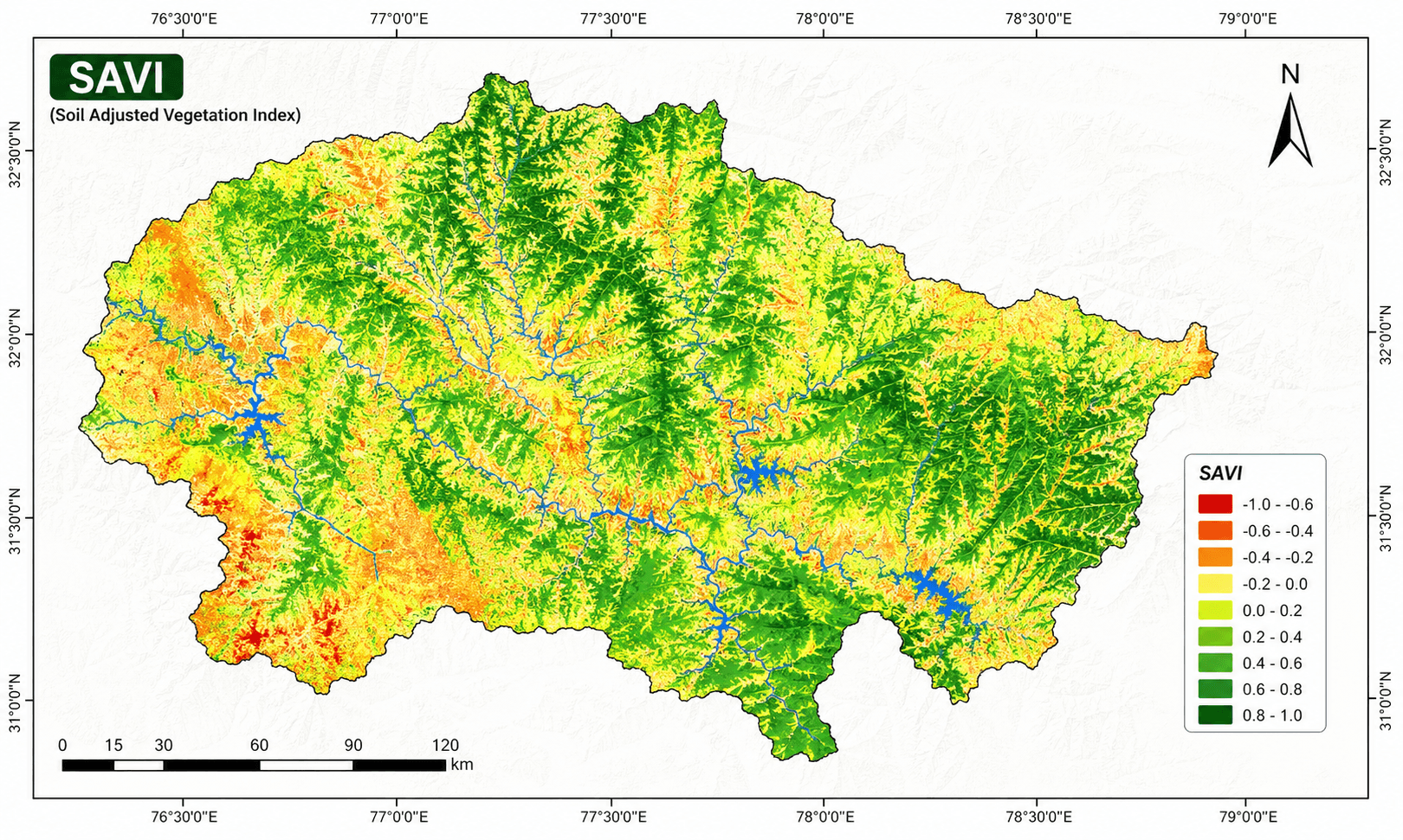
SAVI (Soil-Adjusted Vegetation Index)
((NIR minus Red) / (NIR plus Red plus L)) x (1 plus L)
Corrects NDVI for exposed soil brightness, useful early in the season when canopy cover is still sparse.

GNDVI (Green NDVI)
(NIR minus Green) / (NIR plus Green)
More sensitive to chlorophyll concentration than standard NDVI, useful for nitrogen-status checks mid-season.
EVI (Enhanced Vegetation Index)
2.5 x (NIR minus Red) / (NIR plus 6Red minus 7.5Blue plus 1)
Reduces atmospheric noise and canopy-background effects, and holds up better than NDVI in dense, high-biomass crops.
| Index | Full name | Primary use |
|---|---|---|
| CWSI | Crop Water Stress Index | Thermal-based irrigation scheduling |
| NDMI | Normalized Difference Moisture Index | Canopy water content, separating drought stress from other causes |
| NMDI | Normalized Multi-band Drought Index | Soil and vegetation drought assessment together |
| LAI | Leaf Area Index | Canopy coverage and biomass modeling |
| NNI | Nitrogen Nutrition Index | Fertilizer prescription planning |
| CCCI | Canopy Chlorophyll Content Index | Nitrogen-stress detection |
| REIP | Red-Edge Inflection Point | Chlorophyll and stress trend tracking |
| OSAVI | Optimized Soil-Adjusted VI | Sparse-canopy monitoring |
| TCARI/OSAVI | Transformed Chlorophyll Absorption Ratio Index / OSAVI | Identifying chlorotic (nutrient-deficient) zones within a field |
Case studies for satellite farming in production
The two programs below show what this looks like once imagery is tied to an actual operating decision, not just a report.

China's wheat belt and regional yield forecasting
Multi-temporal satellite imagery and AI tracked wheat development from germination through maturity across major growing regions, flagging drought stress early enough to inform harvest and logistics planning at scale.
- Tracked crop development at every key growth stage
- Detected drought stress and nutrient deficiency ahead of visible symptoms
- Fed AI yield models trained against ground-truth data for regional forecasting
Henan Province daily soil-moisture monitoring
Field-scale soil-moisture mapping, refreshed daily, triggered automated irrigation alerts that told growers exactly when and where to water, replacing a calendar-based schedule with a data-driven one.
- Mapped soil moisture at field scale every day using SAR data unaffected by cloud cover
- Sent automated alerts telling growers exactly when and where irrigation was needed
- Replaced a fixed calendar-based watering schedule with a data-driven one
Industry benchmarks
Beyond these two programs, publicly reported results from satellite-driven precision-agriculture deployments elsewhere in the industry show the range of impact once imagery is tied directly to a variable-rate or scheduling decision.
Input cost reduction reported from variable-rate nitrogen application guided by satellite-derived vigor maps.
Reduction in pesticide-treated acreage after switching from blanket spraying to satellite-flagged pest zones.
Insurance claim turnaround using pre and post-event NDVI in place of full manual field inspection.
Earlier detection of nitrogen deficiency and poor-emergence zones when combining NDVI, NDRE, and MSAVI over a season.
Satellite vs. drone vs. ground scouting
None of the three replaces the others. The efficient setup uses satellite imagery as the standing baseline and reserves drones and ground scouting for the specific zones satellite data flags as worth a closer look.

| Factor | Satellite | Drone | Ground scouting |
|---|---|---|---|
| Coverage per pass | Whole farm or region | Single field | A few acres per hour |
| Best resolution | 25 cm to 30 m | 1 to 5 cm | Direct observation |
| Revisit frequency | Daily to monthly | On demand | On demand, labor-limited |
| Weather dependency | None with SAR, optical needs clear sky | Needs flyable weather | Needs safe field access |
| Cost at scale | Lowest per hectare | Moderate, scales with acreage | Highest at scale (labor) |
| Best for | Trend detection, triage, regional monitoring | Plant-level detail, spot-checks | Ground-truthing, physical sampling |
Key takeaways
- Multispectral and Red Edge imagery catch crop stress, pests, and disease days to weeks before they become visible on the ground.
- Radar (SAR) satellites image through cloud, rain, and darkness, which matters most for wet-season soil-moisture monitoring.
- AI-driven yield models now reach about 85% accuracy at the county level, and crop-type classification tops 90%.
- Landsat's archive, dating back to 1982, turns a single field into a multi-decade productivity and soil-health record.
- Onboard AI on newer satellites can shorten tasking-to-delivery time to about 1 to 1.5 hours.
Frequently asked questions
How does satellite imagery work in agriculture?
Satellites measure how much light a crop canopy reflects across different wavelengths, visible, near-infrared, short-wave infrared, and, for radar sensors, microwave. Since healthy, well-watered vegetation reflects light differently than stressed or sparse vegetation, software converts those reflectance values into vegetation indices like NDVI, NDMI, and NDRE, turning a raw satellite pass into a color-coded map that flags exactly which zones of a field need attention.
What is satellite imagery in precision agriculture?
It is the use of optical, multispectral, thermal, and radar data captured from orbit to monitor crop health, soil moisture, and field conditions at the scale of individual management zones. Agronomists convert the raw bands into vegetation indices such as NDVI and NDRE to guide irrigation, fertilization, and pest-control decisions without a physical site visit.
How accurate is satellite crop monitoring?
Yield models that combine multispectral vegetation indices with biophysical growth modeling reach roughly 85% accuracy at the county level, and AI-based crop-type and land-use classification now exceeds 90% accuracy in commercial deployments.
What resolution do I need for farm-level analysis?
For whole-field trend monitoring, 10 m open-access Sentinel-2 data is usually enough. For within-field scouting, sub-meter to 50 cm imagery is preferred, and for equipment-level tasks such as spotting a blocked emitter or a specific weed patch, 25 to 30 cm very-high-resolution imagery is the right tier.
Can satellite imagery see through clouds?
Optical satellites cannot. That is why cloud-prone growing regions rely on Synthetic Aperture Radar (SAR) satellites such as Sentinel-1, which transmit their own microwave pulses and can image the ground through cloud, rain, or full darkness.
What is the difference between NDVI and NDRE?
NDVI uses red and near-infrared light and is best for general biomass and vigor tracking, but it saturates in dense, closed canopies. NDRE uses the red-edge band instead of red light, making it more sensitive to chlorophyll and nitrogen status in mature, high-biomass crops where NDVI has already plateaued.
How often is new satellite imagery available for a farm?
Cadence ranges from daily to monthly depending on the source. Commercial very-high-resolution constellations such as SuperView Neo and TripleSat deliver daily field updates for active-season crop management, open-access Sentinel-2 revisits most farmland every 3 to 5 days for weekly-range monitoring, and Landsat's 8 to 16 day cycle provides a monthly-equivalent baseline. Tasked acquisitions with onboard AI processing can be delivered in as little as 1 to 1.5 hours.
Can satellite imagery replace drones or ground scouting?
No, they solve different problems. Satellites are the most cost-effective way to monitor entire farms or regions on a recurring schedule, while drones deliver centimeter-level detail on a single field on demand. Most programs use satellite data to flag which zones need a closer look, then send a drone or scout only there.
How is precision agriculture different from traditional farming?
Traditional farming typically applies one seeding rate, irrigation schedule, and fertilizer dose across an entire field. Precision agriculture uses satellite-derived vegetation and moisture indices to vary those inputs zone by zone within the same field, applying more where the data shows a real return and less where it does not.
Can satellite data be used for crop insurance and subsidy claims?
Yes. Insurers and government agencies use before-and-after NDVI comparisons and historical archive imagery to remotely verify hail, flood, and drought damage, confirm land use and field boundaries, and validate subsidy eligibility without inspecting every field in person.
What is satellite farming?
Satellite farming is another term for satellite-based precision agriculture, using orbital imagery and derived vegetation indices, combined with GPS-guided equipment, to manage planting, irrigation, fertilization, and pest control at the sub-field level instead of treating an entire farm uniformly.
Sources and further reading
- ESA Copernicus: Sentinel-1 (SAR) and Sentinel-2 (multispectral) mission specifications
- NASA and USGS: Landsat 4 to 9 mission history and archive access
- China Siwei and 21AT: SuperView Neo, TripleSat, and Beijing-3 series satellite specifications
- Industry market analyses on precision-agriculture adoption and satellite-monitoring market size, 2026 (global precision agriculture market estimated near $13 billion in 2026)
- Sentinel Hub / ESA: NDMI and vegetation water-content index documentation
Ready to see your fields from orbit?
Search our live archive or request new tasking over your area, whether optical, multispectral, or SAR imagery. No account needed to get a first estimate.


