

Hyperspectral Imaging in Mineral Exploration: Mapping Gold and Copper Ore
On this page
- What hyperspectral imaging actually measures
- Hyperspectral vs. multispectral: why the extra bands matter
- Mineral and ore signatures a hyperspectral satellite can map
- Satellites and sensors used for hyperspectral mineral mapping
- From raw satellite data to a ranked drill target
- 01. Data ingestion and pre-processing
- 02. Spectral extraction and PCA
- 03. Deep learning and ground-truth matching
- 04. Integrated prospectivity output
- 05. Turnaround and deliverables
- Why exploration teams are adding hyperspectral to the toolkit
- Cost, labor, time, and responsibility: satellite-led vs. ground-first exploration
- Case studies: hyperspectral exploration in the field
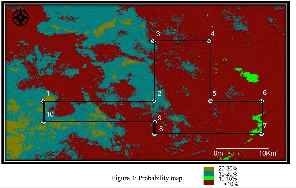
- West Africa, Reguibat Shield: ranking 10 gold targets
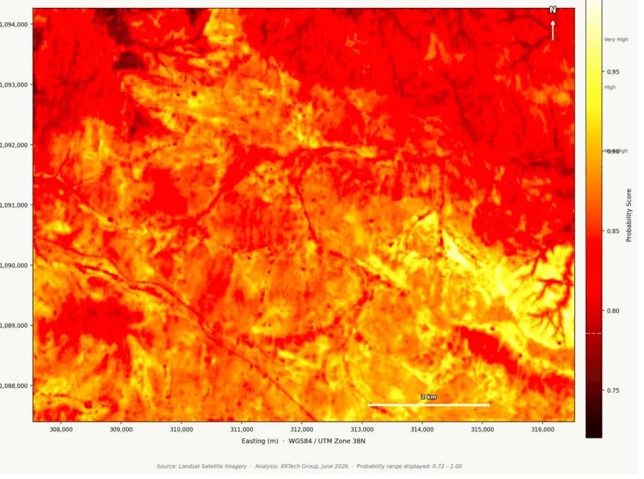
- Tanzania, Lake Victoria Gold Belt: validated targets in under 20 days
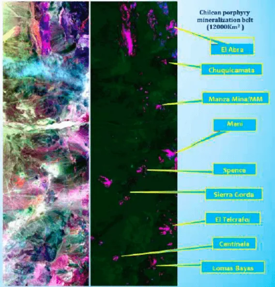
- Chile, Andean copper belt: reprioritizing a drilling schedule
- Hyperspectral satellite vs. drone vs. ground geochemical sampling
- Frequently asked questions
- Sources and further reading
Hyperspectral imaging in mineral exploration works like a remote chemical fingerprint reader. A hyperspectral satellite does not take a picture of a concession, it takes a chemical reading of one. Instead of the three or four broad color bands a normal camera or multispectral satellite records, a hyperspectral sensor splits reflected sunlight into hundreds of narrow, continuous bands between 400 and 2500 nanometers. Clays, oxides, carbonates, and sulfates each absorb and reflect that light in a distinct pattern, the same way a fingerprint is distinct from person to person. Mining and exploration teams use that pattern to map the alteration halos around gold, copper, and base-metal deposits, and the iron oxide zones that mark oxidized ore, across an entire concession before a single drill rig moves.
Quick answer
Hyperspectral imaging maps mineral deposits by measuring how surface rock and soil reflect light across hundreds of narrow spectral bands, revealing the exact clay, oxide, and carbonate minerals that form around gold, copper, iron ore, and other metal systems. Because these alteration minerals are invisible in ordinary photos, hyperspectral satellites let geologists rank drill targets across a whole concession in days instead of the months a ground survey would take.
What hyperspectral imaging actually measures
Every mineral reflects and absorbs light in its own pattern, largely driven by the metal-hydroxyl and carbonate bonds in its crystal structure. A standard photo, or a multispectral satellite with five to fifteen broad bands, cannot separate those patterns because each band blends dozens of narrow absorption features together. A hyperspectral sensor keeps those features intact, recording a continuous spectral curve for every pixel on the ground and comparing it against known mineral reference spectra.
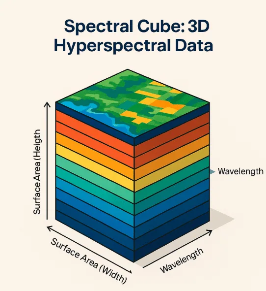
Three spectral ranges do most of the work in mineral exploration:
- Visible and Near-Infrared (VNIR, 400 to 1000 nm): maps iron oxides such as hematite and goethite, and gives an early read on oxidation zones.
- Short-Wave Infrared (SWIR, 1000 to 2500 nm): the workhorse range for exploration, sensitive to the hydroxyl-bearing clays and carbonates that halo hydrothermal ore systems.
- Thermal Infrared: supports lithological mapping by reading the emissivity signature of silicate rock-forming minerals such as quartz and feldspar.
Hyperspectral vs. multispectral: why the extra bands matter
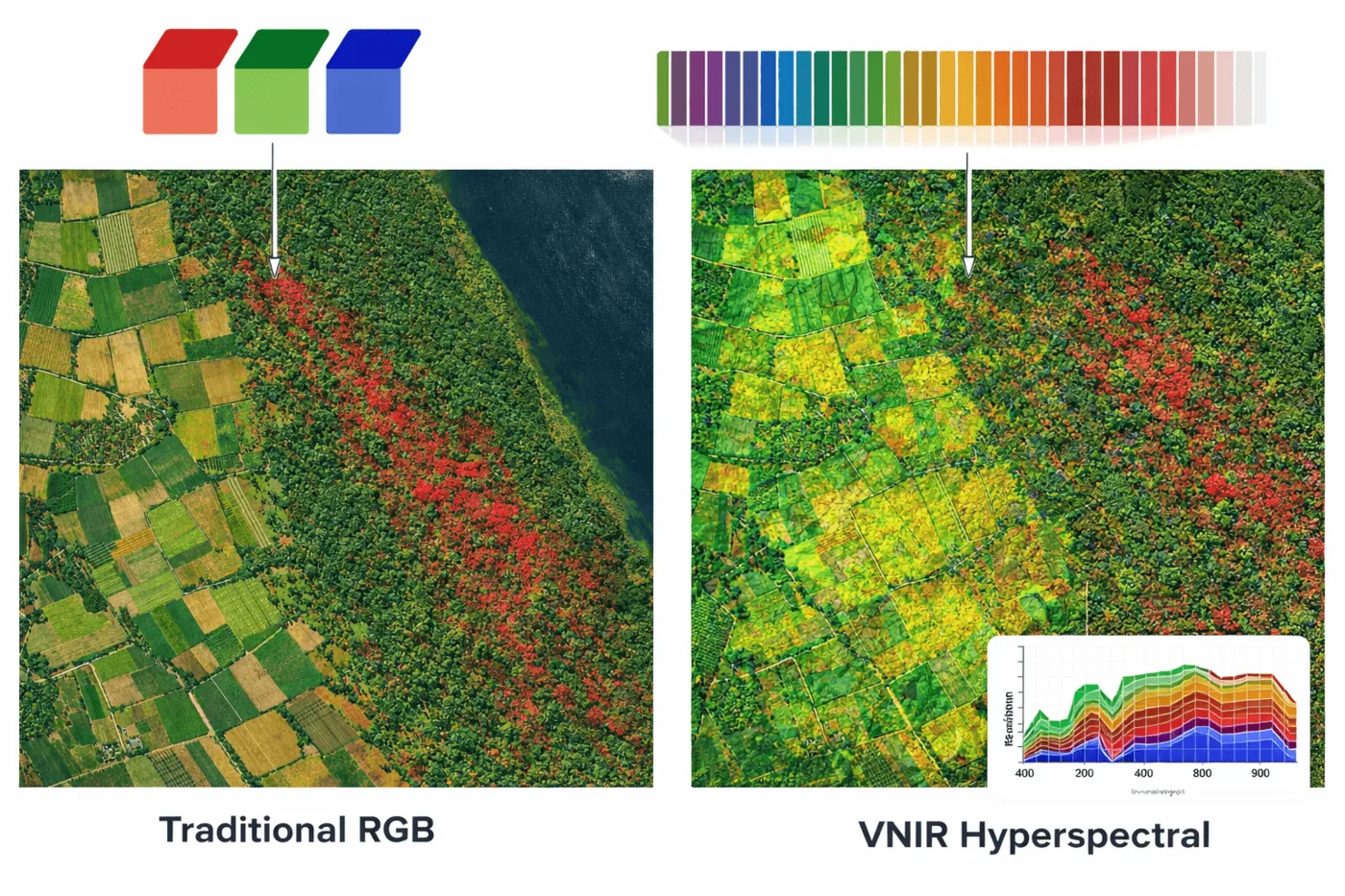
A multispectral satellite can tell you there is a color anomaly. A hyperspectral satellite can tell you which mineral is causing it.
| Factor | Multispectral imaging | Hyperspectral imaging |
|---|---|---|
| Number of bands | 5 to 15 broad bands | 150 to 330-plus narrow, continuous bands |
| Mineral detection | Broad alteration zoning only | Identifies specific mineral species and mixtures |
| Data type | Qualitative color anomaly | Quantitative spectral match against reference libraries |
| Best use | Reconnaissance-level screening over huge areas | Target-grade mapping of alteration, lithology, and structure |
| Ground-truth accuracy | Requires field verification before ranking targets | Approaches lab-grade mineral identification directly from orbit |
Mineral and ore signatures a hyperspectral satellite can map
The table below covers the mineral groups exploration teams track most, and what each one tells a geologist about a concession.
| Signature group | Minerals detected | What it indicates | Relevant deposit types |
|---|---|---|---|
| Hydroxyl-bearing clays | Kaolinite, sericite, illite | Hydrothermal alteration halo around a mineralizing system | Gold, copper, base-metal, lithium |
| Chlorite and epidote | Chlorite, epidote | Propylitic alteration, the outer edge of a porphyry system | Porphyry copper and gold |
| Carbonates | Calcite, dolomite, ankerite | Distal alteration and fluid pathway signatures | Orogenic gold, carbonate-hosted deposits |
| Iron oxides | Hematite, goethite, jarosite | Oxidized gossan, a surface marker of buried sulfides | Iron ore, oxidized copper and gold |
| Structural and lithological units | Surface rock and soil type mapping | Faults, shear zones, and fluid pathways that control ore placement | All hydrothermal deposit types |
Satellites and sensors used for hyperspectral mineral mapping
Hyperspectral data for exploration comes from a small set of dedicated platforms, each suited to a different stage of a program, from wide regional screening to a tighter, higher-resolution look at a shortlisted target.
| Satellite / sensor | Type | Bands / range | Resolution and notes |
|---|---|---|---|
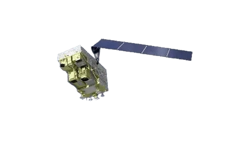
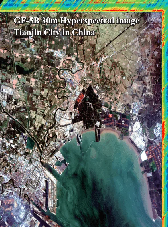
| GF-5 / GF-5B (AHSI) | Hyperspectral | 330 bands, 400 to 2500 nm | 30 m resolution, 60 km swath, regional alteration mapping |
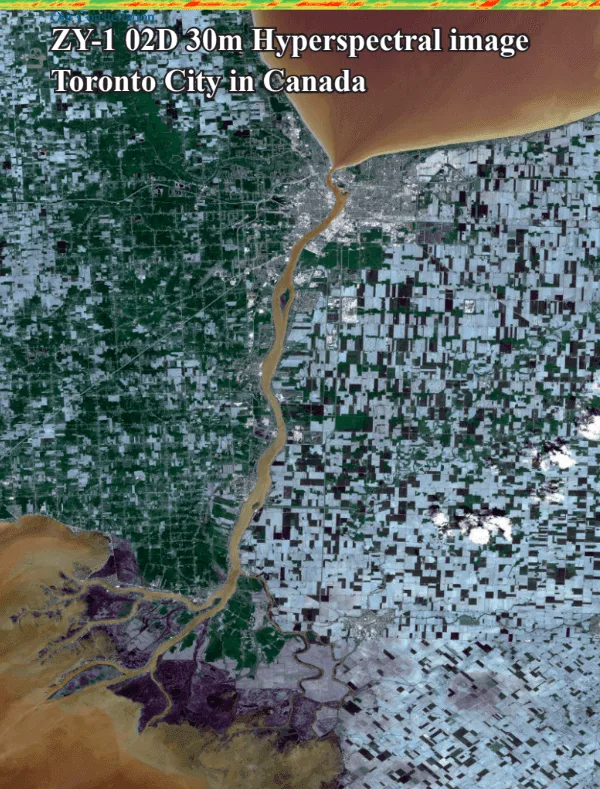
| ZY-1 02D / 02E | Hyperspectral + panchromatic | 166 channels, 400 to 2500 nm | 30 m hyperspectral paired with a 2.5 m panchromatic camera for spatial context |
| Wyvern Constellation | Hyperspectral (VNIR) | 31 bands | 5.3 m Ground Sampling Distance at nadir, commercial-grade target detail |
| SuperView-2 (GFDM) | Optical, expanded multispectral | 1 panchromatic + 8 bands, incl. Purple, Yellow, Red Edge | Complements hyperspectral data for spatial and material context |
From raw satellite data to a ranked drill target
Spectral data on its own is not a target list. It becomes one through a defined processing pipeline, run here through XRTech's Khaza'in hyperspectral intelligence platform.
01. Data ingestion and pre-processing
Satellite datasets go through full radiometric calibration, atmospheric correction, cloud and haze masking, and terrain illumination normalization, so a shadow on one hillside is not mistaken for an alteration anomaly on another.
02. Spectral extraction and PCA
Band ratios and Principal Component Analysis pull the subtle alteration signal out of the background noise in the raw spectral cube, sharpening anomalies that would otherwise sit below the visual threshold.
03. Deep learning and ground-truth matching
Proprietary deep learning models, calibrated against physical ground sample spectra, classify each pixel's mineral probability rather than relying on a simple threshold cutoff.
04. Integrated prospectivity output
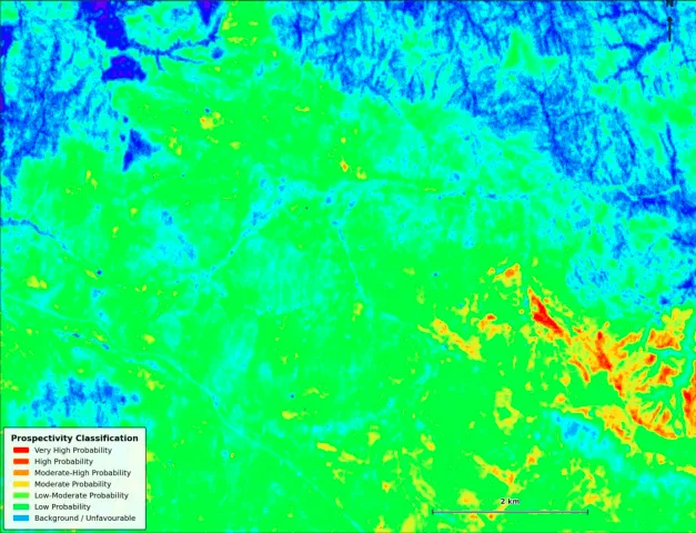
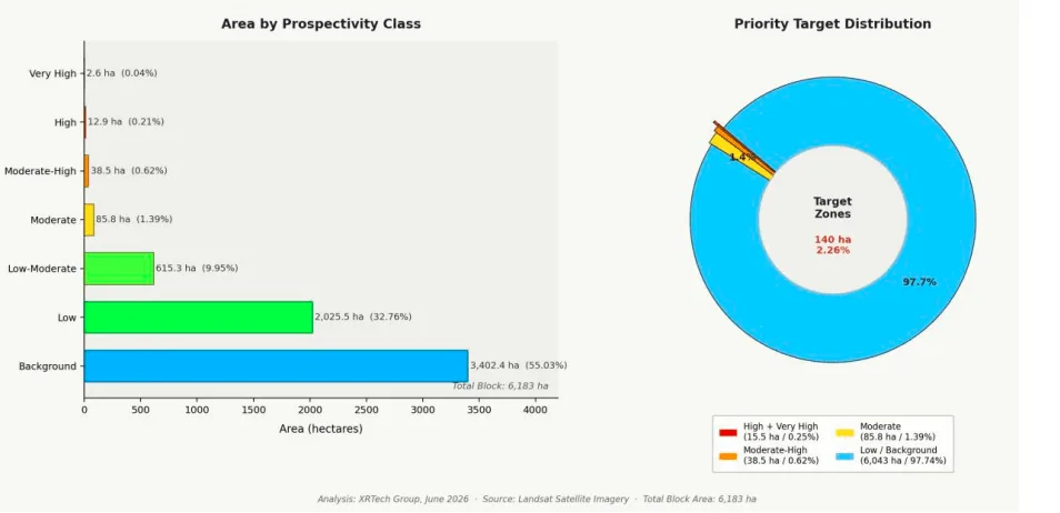
Alteration layers, fault intersections, host rock geology, and DEM elevation models are combined into a single ranked target map, so a target has to satisfy multiple independent evidence layers before it makes the list.
05. Turnaround and deliverables
For concessions under 100 km², the finished package, color-coded mineral maps, target GPS coordinates, confidence layers, and GIS shapefiles, is typically delivered in 2 to 3 days.
Why exploration teams are adding hyperspectral to the toolkit
- Reduced exploration costs: Preliminary ground surveys across vast, remote concessions become unnecessary once satellite data narrows the search to high-probability zones.
- Accelerated timelines: Early-stage exploration that used to take years or months compresses down to days of desk-based analysis before field crews are mobilized.
- De-risked investment: Quantitative, data-backed targets give a stronger basis for drilling schedules and stakeholder negotiations than a geologist's field notes alone.
- Environmental and tailings monitoring: The same sensors that find a deposit also monitor site disturbance, detect chemical or acid leakage, track tailings dam health, and support post-closure land rehabilitation.
Results from the field
These are outcomes from actual hyperspectral exploration programs, not lab projections.
Turnaround for a full prospectivity report, target coordinates, and GIS shapefiles on concessions under 100 km².
Calculated gold-presence probability at the top-ranked target zones in a West Africa deep-learning model run.
Time to validated gold and alteration targets in the Tanzania Lake Victoria Gold Belt program.
High-confidence drill targets ranked from a single concession-wide hyperspectral and DEM fusion model.
Cost, labor, time, and responsibility: satellite-led vs. ground-first exploration
The practical difference between the two approaches shows up most clearly in what it costs to reach the first confirmed target, and who carries the risk while getting there.
| Factor | Ground-first exploration | Hyperspectral satellite-led exploration |
|---|---|---|
| Cost | High upfront cost to mobilize crews, camps, and transport before any target is confirmed | Desk-based analysis of existing satellite data narrows the search before field spending starts |
| Labor | Dozens of geologists and samplers for months of grid-based fieldwork | A small remote-sensing and geology team reviewing AI-ranked outputs |
| Time | Months to years to cover a large or remote concession on foot | A finished target report before a single field crew is mobilized |
| Responsibility and safety | Field crews exposed to remote terrain, wildlife, and access risk across the whole concession | Field teams are sent only to zones a model has already flagged as high-probability |
| Environmental footprint | Access roads, trenching, and camp construction disturb land before value is confirmed | No ground disturbance until a target is confirmed and drill-ready |
| Government and compliance | Manual field reports and periodic site audits | A continuous satellite record supports land-use, tailings, and reclamation reporting to regulators |
Case studies: hyperspectral exploration in the field
Three programs show how this plays out once satellite data is tied to an actual drilling or monitoring decision.
West Africa, Reguibat Shield: ranking 10 gold targets
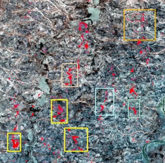
Deep learning models fused satellite spectral data with digital elevation models across hundreds of square kilometers of concession, pinpointing 10 high-confidence gold target zones.
- Calculated gold-presence probability reached up to 21.69% at the top-ranked zones
- Combined alteration mapping, structural data, and elevation modeling into one ranked target list
- Narrowed a regional concession down to a short, prioritized drilling shortlist
Tanzania, Lake Victoria Gold Belt: validated targets in under 20 days
Hyperspectral analysis rapidly identified gold mineralization and hydrothermal alteration zones adjacent to existing artisanal workings, delivering validated exploration targets in under 20 days.
- Mapped alteration zones directly adjacent to known artisanal gold workings
- Delivered a validated target list well inside a one-month turnaround
- Gave the exploration partner a data-backed basis to prioritize follow-up sampling
Chile, Andean copper belt: reprioritizing a drilling schedule
Hyperspectral mapping of hydrothermal alteration and iron anomalies across a major porphyry copper belt let an exploration partner reprioritize its drilling schedule and skip months of field logistics that would otherwise have gone into checking lower-probability ground first.
- Mapped alteration and iron-oxide anomalies across a 12,000 km² porphyry belt
- Cross-referenced results against known deposits along the same trend
- Let the partner move drilling budget toward the highest-probability zones first
Hyperspectral satellite vs. drone vs. ground geochemical sampling
None of the three replaces the others. The efficient sequence uses satellite data to screen the whole concession, then reserves drones and ground sampling for the specific zones worth a closer look. In an active open pit, a drone-mounted hyperspectral scanner can also build a 3D model of an exposed mine wall, giving a mineral reading across a rock face that a satellite, looking straight down, cannot see at all.
| Factor | Satellite hyperspectral | Drone hyperspectral | Ground geochemical sampling |
|---|---|---|---|
| Coverage per pass | Whole concession or region | Single pit or outcrop | A few sample points per day |
| Best resolution | 5.3 m to 30 m | Centimeter-level | Exact point sample |
| Turnaround | A few days per concession, regardless of size | Days, weather dependent | Weeks, limited by lab assay queues |
| Cost at scale | Lowest per km² | Moderate, scales with flight time | Highest per data point |
| Best for | Regional screening and target ranking | Confirming detail on a flagged zone | Confirming grade at a specific point |
Key takeaways
- Hyperspectral sensors capture 150 to 330-plus narrow bands from 400 to 2500 nm, fine enough to tell individual clay, oxide, and carbonate minerals apart, not just detect vegetation and rock in broad strokes.
- Gold, copper, and lithium deposits are usually found indirectly, by mapping the alteration halo of kaolinite, sericite, illite, chlorite, and carbonate minerals that surrounds them, not the ore itself.
- Iron oxides such as hematite, goethite, and jarosite mark oxidized gossans, a classic surface signal of buried sulfide mineralization.
- A ranked, GPS-coded target map with GIS shapefiles is realistic within days rather than the months a ground-first program needs to cover the same concession.
- Field programs have produced up to 10 ranked gold targets from a single concession, and validated results in under 20 days, with every target still needing drill confirmation before it counts as a discovery.
Frequently asked questions
What is hyperspectral imaging in mineral exploration?
Hyperspectral imaging captures hundreds of narrow, continuous spectral bands from 400 to 2500 nm to identify the exact clay, oxide, and carbonate minerals present on the surface. Exploration teams use it to map the hydrothermal alteration halos around gold, copper, and base-metal deposits, and the iron oxide zones that mark oxidized ore, without a site visit.
How does hyperspectral imaging detect gold deposits?
Gold deposits are rarely detected directly. Instead, hyperspectral sensors map the hydrothermal alteration minerals, such as kaolinite, sericite, illite, and chlorite, that halo a gold-bearing system. AI models then combine that alteration map with fault structures and elevation data to rank the most probable target zones.
What is the difference between hyperspectral and multispectral imaging for mining?
Multispectral satellites capture 5 to 15 broad bands, enough for reconnaissance-level alteration zoning. Hyperspectral satellites capture 150 to over 330 narrow, continuous bands, enough to identify specific mineral species and mixtures with near lab-grade accuracy directly from orbit.
Which minerals can hyperspectral satellites map?
Common targets include hydroxyl-bearing clays such as kaolinite, sericite, and illite, chlorite and epidote, carbonates such as calcite and dolomite, and iron oxides such as hematite, goethite, and jarosite. Together these map alteration halos, oxidation zones, and lithological units relevant to gold, copper, iron ore, and lithium exploration.
How much does hyperspectral mineral exploration cost compared to ground surveys?
A satellite-based hyperspectral survey replaces the preliminary ground surveys that would otherwise be needed to screen an entire concession, cutting the cost of mobilizing crews, camps, and transport before a single target is confirmed. Field spending is then focused only on the zones the analysis ranks as high-probability.
How long does a hyperspectral mineral exploration survey take?
For concessions under 100 square kilometers, a full analysis, including alteration mapping, deep learning classification, and a ranked target map with GIS shapefiles, is typically delivered in 2 to 3 days. Field validation programs have produced confirmed targets in under 20 days.
Can hyperspectral imaging replace exploration drilling?
No. Hyperspectral imaging shows that alteration minerals consistent with a mineral system are present at the surface, not the ore grade or depth below it. It is used to prioritize where a limited drilling budget should go, not to replace the drilling and geochemical assay that confirm a deposit.
What satellites capture hyperspectral data for mining exploration?
Dedicated hyperspectral platforms include GF-5 and GF-5B, which carry a 330-band Advanced Hyperspectral Imager at 30 m resolution, ZY-1 02D and 02E with a 166-channel camera paired with 2.5 m panchromatic imagery, and the Wyvern Constellation, which delivers 31-band VNIR data at 5.3 m resolution.
Can hyperspectral imaging monitor tailings dams and environmental compliance?
Yes. The same sensors used for exploration also monitor site disturbance, detect chemical or acid leakage, track tailings dam health over time, and support post-closure land rehabilitation reporting to regulators.
Exploration is one stage of a much longer satellite record. For how the same archive later tracks pit development, tailings dam safety with InSAR, and closure rehabilitation, see our guide to how satellites monitor mining from exploration to closure. And for how the broader, faster screening pass that usually comes before a hyperspectral survey works, see what multispectral imaging is and how it compares to hyperspectral data. For the structural, radar, and elevation data that runs alongside this spectral layer, plus a fresh 2026 case study from the DRC Copperbelt, see our guide to how satellites detect minerals and target prospects.
Sources and further reading
- China Siwei and CNSA: GF-5 / GF-5B Advanced Hyperspectral Imager (AHSI) mission specifications
- China Siwei and 21AT: ZY-1 02D / 02E and SuperView-2 (GFDM) sensor specifications
- Wyvern: hyperspectral constellation spectral band and resolution specifications
- XRTech Group Khaza'in platform: field case studies across West Africa, Tanzania, and Chile, 2026
Ready to scan your concession from orbit?
Search our hyperspectral and multispectral archive or request new tasking over your concession, then get a ranked target map back in days. No account needed to get a first estimate.


