Satellite Imagery Revisit Rates, From Seconds to Weeks
On this page
- What Is Revisit Rate
- What Decides How Often a Satellite Updates
- Geostationary Satellites Update Continuously
- Large Constellations Multiply Daily Passes
- Very High-Resolution Optical Satellites, Daily to 5-Day Revisit
- SAR Satellites Update Regardless of Weather
- Hyperspectral Sensors Update Less Often
- Continuous Monitoring vs a One-Off Capture
- Free vs Commercial, Who Updates Faster
- Why Archive Imagery Still Matters
- What Happens to Revisit Rate in a Flood, Hurricane, or Wildfire
- From Capture to Delivery, How Fast You Actually Get the Image
- How XRTech Delivers Fast, Flexible Revisit
- Frequently asked questions
- Sources and further reading
Quick answer
There's no single update speed, it depends on the satellite. A geostationary satellite like GF-4 refreshes the same region every 20 seconds. A large multi-satellite constellation like the SuperView Neo system revisits a target zone up to 25 times a day. A single very high-resolution satellite typically comes back every 1 to 5 days. All-weather radar satellites update on their own schedule, 4 to 10 days, regardless of cloud or darkness. Free public satellites like Sentinel-2 and Landsat update every 5 to 8 days combined across their paired satellites. The right answer for your project depends on whether you need one fresh image, a daily watch, or a years-long historical record, covered section by section below.
What Is Revisit Rate
Revisit rate (also called update cadence) is how often a satellite or constellation can capture a new image of the exact same spot on Earth. A revisit rate of "5 days" means that specific location gets re-imaged roughly every 5 days, not that the satellite is idle in between, it's busy imaging everywhere else on its orbit in the meantime. A faster revisit rate means a shorter gap between two images of the same place, which is what makes a recent change, like new construction, a fire, or crop stress, catchable sooner.
Revisit rate is not the same as resolution (how much detail each image shows) or delivery speed (how fast you receive the image after it's captured), both covered further down.
What Decides How Often a Satellite Updates
Three things set the update speed for any given satellite or constellation.
| Factor | Effect on update speed |
|---|---|
| Orbit type | Geostationary orbit stares at one region continuously. Low Earth orbit sweeps past and comes back on a fixed cycle. |
| Constellation size | More satellites sharing the same orbit means more passes over the same spot each day. |
| Sensor type | Optical sensors need sunlight and clear sky. Radar sensors work in any weather, day or night, on their own fixed schedule. |
Geostationary Satellites Update Continuously
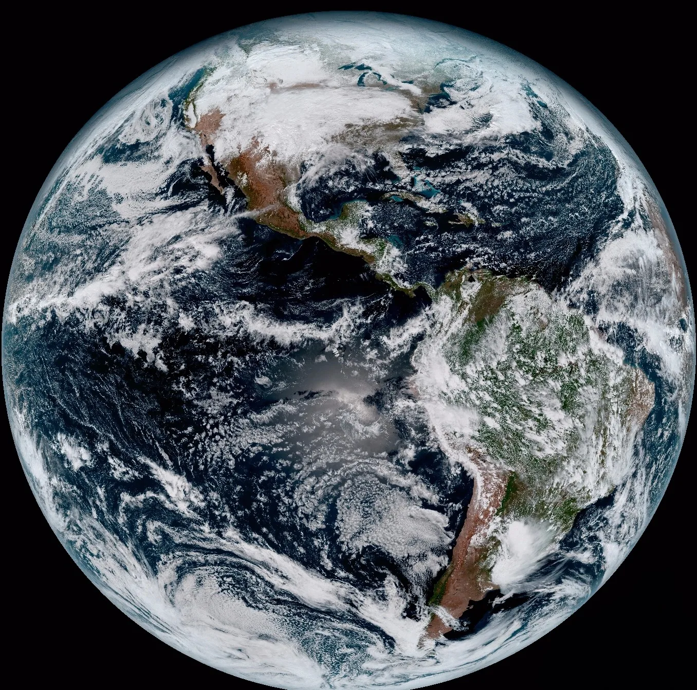
A geostationary satellite orbits at 36,000 km, matching Earth's rotation, so it holds one fixed region in view instead of sweeping past it once per orbit.
- GF-4. Refreshes optical (50 m) and Mid-Wave Infrared (400 m) imagery every 20 seconds over its fixed region, built for real-time disaster and wildfire tracking.
- GOES weather satellites. NOAA's GOES series refreshes a full-disk view roughly every 10 minutes, with a further 20 to 40 minute lag before it's viewable, and can refresh a smaller storm-tracking sector even faster. The tradeoff is resolution, GOES imagery runs 250 m to 2 km per pixel, built for tracking weather systems, not identifying ground objects.
Large Constellations Multiply Daily Passes
One low-orbit satellite only passes over a given spot every few days. Put several satellites in the same orbital family, spaced apart, and the combined fleet passes over that same spot far more often.
- SuperView Neo system. China Siwei's SuperView Neo constellation, nine satellites in orbit as of 2026 and growing toward a planned 28, revisits a target zone up to 25 times a day, with current combined daily coverage around 5.8 million km².
- Why more satellites beats a faster single satellite. A satellite can't outrun its own orbit, but a second satellite on a different point in the same orbital track fills the gap between the first satellite's passes. That's the entire logic behind every large Earth-imaging constellation.
Need a target revisited multiple times a day?
Task the SuperView Neo constellation for up to 25 passes a day over one zone, or search existing archive first.
Very High-Resolution Optical Satellites, Daily to 5-Day Revisit
| Satellite | Resolution | Revisit |
|---|---|---|
| SuperView Neo-1 | 0.25 to 0.3 m | Daily, at middle and high latitudes |
| SuperView-1 | 0.5 m | Daily |
| TripleSat Constellation | 0.8 m | Near-daily |
| SuperView-2 | 0.42 m | 3 days |
| GF-6 / GF-1 | 2 m / 8 m | 4 days |
| ZY-3 | 2.1 m, stereo | 1 to 2 days |
| GF-7 / GF-2 | 0.65 m / 0.8 m | 5 days |
Resolution and revisit usually trade against each other across a single fleet, the sharpest sensors tend to sit on satellites with slightly longer single-satellite revisit, made up for by flying several at once.
SAR Satellites Update Regardless of Weather
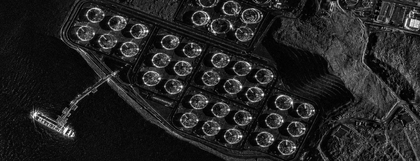
Synthetic Aperture Radar (SAR) transmits its own microwave signal instead of relying on sunlight, so cloud cover, fog, smoke, and darkness don't block a pass.
| Satellite | Band and resolution | Revisit |
|---|---|---|
| GF-3 | C-band, down to 1 m | 10 days |
| LT-1 | L-band, 3 m, InSAR-capable | 8 days single satellite, 4 days in 2-satellite formation |
A SAR revisit figure doesn't shift with cloud cover the way an optical one effectively does. An optical satellite's quoted revisit assumes a clear sky, a cloudy stretch can push the real usable gap much longer, while SAR delivers a usable pass on schedule regardless.
Hyperspectral Sensors Update Less Often
- ZY1-02D. Its WPM camera revisits every 3 days. Its separate 166-band AHSI hyperspectral imager, the one used for detailed biochemical and mineral analysis, runs on its own 26-day cycle.
- GF-5B. A 12-day revisit cycle for its VIMS thermal and SWIR sensor.
- Why the gap. A hyperspectral or thermal sensor records far more data per pixel than a standard optical band, which means a narrower swath and more time between passes over the same spot.
Continuous Monitoring vs a One-Off Capture
"Revisit rate" describes what a satellite is capable of. Whether you actually get that revisit depends on how the order is set up.
| One-off capture | Continuous monitoring | |
|---|---|---|
| What it is | A single tasked image for one date | A standing order that re-tasks the same area on a repeating schedule |
| Best for | Confirming a single event, a one-time survey, a specific closing date | Right-of-way patrols, crop monitoring through a season, construction progress tracking |
| What you get | One scene | An automatically comparable time series, feeding straight into change detection |
A single capture answers "what does this look like right now." A monitoring schedule answers "what changed," which is a different question and needs a repeating order, not a faster satellite.
Free vs Commercial, Who Updates Faster
| Source | Resolution | Update frequency | Cost |
|---|---|---|---|
| GOES | 250 m to 2 km | ~10 minutes, full disk | Free |
| Sentinel-2 | 10 to 20 m | 5 to 6 days combined | Free |
| Landsat 8 + 9 | 15 to 30 m | 8 days combined, 16 days each alone | Free |
| Google Earth / Google Maps | Sub-meter in most urban areas | No fixed schedule, months to several years old depending on location | Free |
| Commercial VHR fleet | 0.25 to 0.8 m | Daily to 5 days per satellite, faster pooled across a constellation | Paid, tasked or archive |
Free sources update fast at coarse resolution, or sharp at a slower cycle, rarely both at once. Commercial VHR fleets are built to close that exact gap, sub-meter detail without waiting a week for the next pass.
Direct answer, Google Earth and Google Maps don't run on a revisit cycle at all. There's no orbiting Google satellite on a fixed schedule, both platforms stitch together imagery licensed from multiple commercial providers, and each location updates independently whenever a provider submits a new capture for that spot. A city center might refresh every few months, a rural area might sit untouched for several years, and there's no way to predict the next update in advance. The only way to check is the date stamp Google shows for that specific location, not a general "Google updates every X" rule, because no such fixed rule exists.
Why Archive Imagery Still Matters
- A single fresh image can't show change. Spotting what's different needs a prior image to compare against, which means archive, not just the newest capture.
- Archive is faster and cheaper than tasking. If a usable recent scene already exists, pulling it from archive skips the wait for a new satellite pass entirely.
- Long baselines need old imagery. Multi-year trend analysis, erosion, urban growth, deforestation, depends on imagery going back years or decades, something no amount of fast revisit on new tasking can substitute for.
For picking between the two for a specific project, see our guide to tasking vs archive search, and for finding a usable clear scene in that archive, see cloud cover in satellite imagery archive search.
What Happens to Revisit Rate in a Flood, Hurricane, or Wildfire
A standard revisit schedule goes out the window the moment a disaster hits. Emergency tasking reorders the queue so the affected area gets imaged again and again, not just on its normal turn.
| Disaster | Main obstacle | What actually gets used |
|---|---|---|
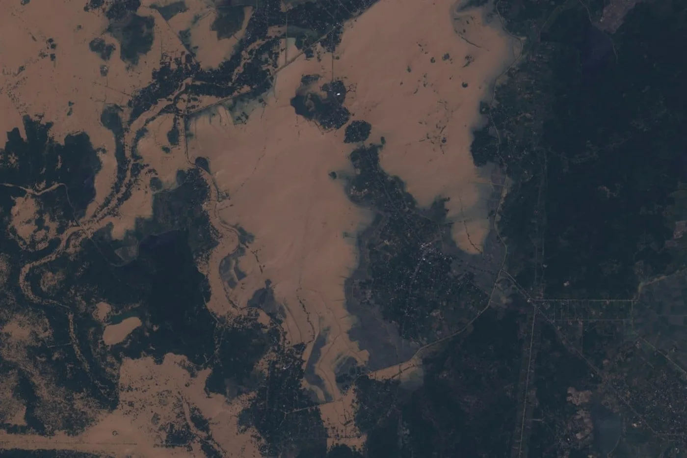
| Flood | Heavy cloud cover almost always sits over the event | SAR (GF-3, LT-1), which images straight through cloud, paired with optical once skies clear for visual confirmation |
| Hurricane | The storm itself blocks optical imaging, and the target keeps moving | Geostationary tracking (GOES, refreshed every ~10 minutes) for the storm path, SAR for post-landfall damage once it's over land |
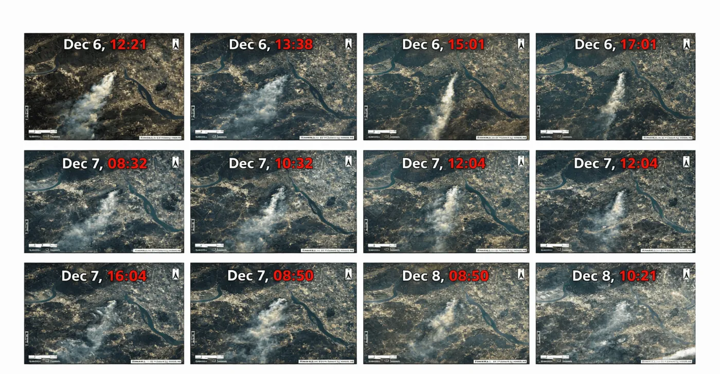
| Wildfire | A fast-moving front changes by the hour | GF-4's geostationary thermal band, refreshed every 20 seconds, for real-time hotspot and smoke-plume tracking |
- Priority tasking, not a faster satellite. The satellite's physical revisit rate doesn't change, what changes is that the disaster zone jumps to the front of the tasking queue and gets re-ordered on every available pass instead of waiting its normal turn.
- Proven turnaround. During the 2023 Derna, Libya flood response, this kind of priority tasking delivered analysis-ready, high-resolution imagery within 24 hours of the event, the fastest confirmed ceiling for emergency delivery.
- Why the sensor choice matters more than usual. A flood or hurricane without SAR in the mix can mean days of waiting for a cloud-free optical pass, exactly the gap all-weather radar is built to close when speed actually matters.
From Capture to Delivery, How Fast You Actually Get the Image
Revisit rate is when the satellite flies over. Delivery speed is when the image actually reaches you, a separate number.
- Tasking uplink. A new tasking request reaches ground stations worldwide within about 3 hours.
- Processing and delivery. XRTech's own cloud processing platform turns a captured scene into an analysis-ready file in about 1 hour, with a typical 1.5-hour response time from request to delivery.
- Emergency collection. Under 24 hours for a critical event, covered in the disaster section above.
- Standard fresh tasking. Typically 4 to 7 days from order to delivery.
- 3D elevation datasets. DEM and DSM products, built from stereo passes, typically deliver in under 21 days.
How XRTech Delivers Fast, Flexible Revisit
- Match the fleet to the need. Daily VHR optical for a single site, SAR for weather-proof coverage, or the SuperView Neo system for up to 25 passes a day over one target zone.
- Set up repeating monitoring. A corridor, field, or site can be placed on a standing tasking schedule, not just a single order, so each new pass compares automatically against the last.
- Archive first, tasking second. Search existing archive before paying for a new capture, most areas already have a usable recent scene.
- Fast delivery either way. Emergency turnaround under 24 hours, standard tasking in 4 to 7 days, DEM products under 21 days.
Find the update speed your project actually needs
See our change detection service for repeating monitoring schedules, or search archive and task fresh capture directly.
Key takeaways
- Update speed depends on orbit, constellation size, and sensor type, not one fixed number. Geostationary satellites refresh in seconds to minutes, large constellations revisit daily or faster, single satellites take 1 to 12 days depending on the sensor.
- GF-4 refreshes every 20 seconds. The SuperView Neo system revisits up to 25 times a day. VHR optical satellites typically return every 1 to 5 days. SAR satellites run 4 to 10 days, unaffected by weather.
- Free sources trade speed for resolution or the reverse, GOES updates every 10 minutes at coarse resolution, Sentinel-2 and Landsat update every 5 to 8 days combined at 10 to 30 m.
- Revisit rate and delivery speed are different numbers. A fast revisit doesn't mean a fast delivery, check both before assuming how current an image will be.
- A single fresh image can't show change on its own. Archive imagery and a repeating monitoring schedule both matter alongside raw revisit speed.
- In a flood, hurricane, or wildfire, emergency tasking reorders the queue so the disaster zone gets imaged on every available pass, not a faster satellite. SAR cuts through flood and storm cloud, GF-4's 20-second geostationary refresh tracks a wildfire front, and this kind of priority tasking delivered imagery within 24 hours during the 2023 Derna, Libya flood.
Frequently asked questions
How often is satellite imagery updated?
It depends on the satellite. Geostationary satellites update every 20 seconds to about 10 minutes. Large constellations like SuperView Neo revisit a target up to 25 times a day. A single very high-resolution satellite typically returns every 1 to 5 days, and SAR satellites run on a fixed 4 to 10 day schedule regardless of weather.
How often are satellite images updated for a specific location?
For a specific point on Earth, revisit depends on which satellite or constellation is tasked. A single commercial VHR satellite typically returns every 1 to 5 days, while a multi-satellite constellation operating together can revisit the same location multiple times in one day.
What is the fastest satellite image update rate?
Geostationary satellites are fastest. GF-4 refreshes its fixed region every 20 seconds. Weather satellites like GOES refresh a full-disk view roughly every 10 minutes, though at far coarser resolution than a high-resolution imaging satellite.
How often do free satellites like Sentinel-2 and Landsat update?
Sentinel-2 updates every 5 to 6 days combined across its paired satellites. Landsat 8 and 9 update every 8 days combined, 16 days each alone. Both trade update speed for free access at 10 to 30 m resolution, slower than most commercial VHR satellites.
Is revisit rate the same as delivery speed?
No. Revisit rate is how often a satellite flies over a location. Delivery speed is how long it takes to receive the processed image afterward, typically 1 to 1.5 hours for cloud processing once captured, up to several hours more for tasking uplink, and 4 to 7 days total for a standard new tasking order.
How fast can satellites image a flood, hurricane, or wildfire?
Emergency tasking can deliver analysis-ready imagery within 24 hours of the event, as happened during the 2023 Derna, Libya flood response. A satellite's normal revisit rate doesn't actually get faster, the disaster zone is simply reordered to the front of the tasking queue on every available pass. SAR handles flood and hurricane cloud cover, while GF-4's 20-second geostationary refresh tracks a fast-moving wildfire front in real time.
Why does archive imagery matter if a satellite updates frequently?
A fresh image on its own can't show what changed, that needs a prior image to compare against. Archive imagery is also faster and cheaper than tasking when a usable recent scene already exists, and it's the only way to analyze change over years or decades.
How often does Google Earth or Google Maps update its satellite imagery?
There's no fixed schedule. Google Earth and Google Maps stitch together imagery licensed from multiple commercial providers, and each location updates independently whenever a provider submits a new capture, not on a set orbital revisit. A city center might refresh every few months, while a rural area can sit unchanged for several years. The only way to check is the date stamp shown for that specific location.
For choosing between a fresh tasked image and existing archive for your project, see tasking vs archive search. For how a satellite actually captures and processes each pass, see how satellite images are taken.
Sources and further reading
- XRTech Group, satellite revisit rate specifications across the SuperView, GF, ZY, and LT-1 fleet
- eoPortal, Sentinel-2 and Landsat 8/9 revisit interval analysis
- NOAA/NASA GOES-R Series, ABI scan mode documentation and full-disk refresh interval
- ESA Copernicus, Sentinel-2 satellite constellation specifications
From a 20-second refresh to a years-long archive
Search existing imagery or task the revisit rate your project actually needs, geostationary, daily VHR, all-weather SAR, or a repeating monitoring schedule.