

Satellite Imagery as Insurance Claims Evidence
On this page
- Why insurers are moving claims assessment off the ground
- Pre-loss risk assessment and disaster baseline verification
- Key applications of satellite imagery in claims assessment
- 01. Rapid disaster impact analysis
- 02. Fraud reduction and boundary verification
- 03. All-weather and nighttime evidence with SAR
- 04. Agricultural and crop loss adjustment
- 05. Construction and builder's risk monitoring
- Before-and-after evidence in practice
- Storm and roof damage
- Flood damage verification
- Wildfire impact assessment
- Property alteration and dispute resolution
- Large-scale catastrophe triage
- Operational and financial benefits for insurers
- Real-world case examples
- Derna, Libya: 24-hour flood extent mapping
- India and Nigeria: crop loss and drought validation
- Frequently asked questions
- Sources and further reading
Satellite imagery has become an essential, legally verifiable source of evidence for insurance companies, changing how carriers handle risk assessment, underwriting, and claims verification. Traditional claim handling still leans on physical site visits, and those are slow, expensive, often unsafe right after a major disaster, and an easy place for a claim to get stuck in the queue. High-resolution Earth observation data and Synthetic Aperture Radar (SAR) give insurers a remote alternative: unbiased, time-stamped geospatial evidence that doesn't wait for a road to reopen.
Quick answer
Satellite imagery serves as insurance claims evidence by comparing pre-loss and post-event images of an insured property to verify whether damage occurred during the policy window, confirm boundaries and unauthorized construction, and measure the extent of flood, wildfire, or storm damage. Optical imagery down to 30 cm resolution documents visible destruction, while SAR penetrates cloud, smoke, and darkness to keep evidence flowing during active weather. Analysis-ready results typically arrive in under 24 hours to 7 days, letting insurers verify claims and prioritize inspections without sending an adjuster into a hazardous or inaccessible area first.
Why insurers are moving claims assessment off the ground
A manual site visit answers one question well, what does this property look like today, but it can't tell an adjuster what the property looked like last month, and it puts a person into conditions that are frequently unstable, flooded, or still smoldering. Satellite and radar data answer both problems at once: an archived "before" image removes the guesswork about when damage happened, and a remote "after" image removes the need to physically enter a disaster zone to get it.
Pre-loss risk assessment and disaster baseline verification
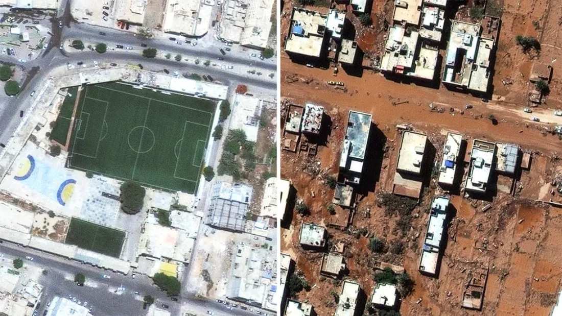
Insurers draw on satellite archives running back to the late 1990s to establish an indisputable "before" picture of a property or asset. That baseline is useful long before a claim is ever filed: at underwriting, it documents roof condition, building footprint, surrounding vegetation, and proximity to a flood zone or other hazard, giving underwriters an objective record instead of a self-reported description. Once a loss does occur, comparing that archival baseline against post-event imagery settles the question adjusters ask most often: did this structural damage, erosion, or land degradation happen during the insured policy window, or was it already there beforehand.
Key applications of satellite imagery in claims assessment
Beyond establishing a baseline, satellite and radar data get applied across several distinct stages of the claims lifecycle, each solving a different problem for adjusters and underwriters.
01. Rapid disaster impact analysis
Following a widespread catastrophe, floods, hurricanes, wildfires, or severe storms, sub-meter optical imagery down to 30 cm resolution lets adjusters evaluate property conditions, measure flood inundation levels, and assess structural destruction across an entire neighborhood at once instead of one address at a time.
02. Fraud reduction and boundary verification
Unbiased satellite data verifies property lines, flags illegal construction or unauthorized additions, confirms how a building is actually being used, and checks unverified claims against objective visual proof, which cuts down on fraudulent or inflated claims without turning every case into an accusation.
03. All-weather and nighttime evidence with SAR
When storm clouds, heavy fog, or dense smoke block a normal optical camera, Synthetic Aperture Radar sends out its own microwave signal and reads ground conditions regardless of daylight or weather. That's what makes SAR reliable evidence during active rainfall or immediately after floodwaters crest, exactly when optical imagery is least available.
04. Agricultural and crop loss adjustment
For farm and crop insurance, multi-spectral satellite imagery tracks soil moisture, vegetation health through indices like NDVI, and drought stress across an entire field or region, giving insurers a way to validate crop loss, yield reduction, and weather-related damage without a manual field-scouting visit for every policy.

05. Construction and builder's risk monitoring
On commercial and residential builder's risk policies, regular satellite revisits track construction milestones and site safety over time, which gives insurers a way to verify progress reports or reconstruct a timeline if a builder's risk claim comes in.
None of this is meant to run without a person. Automated change detection and AI-based damage classification are what let these five applications scale across thousands of properties in the middle of a catastrophe, but the output is a documented starting point for underwriting and claims teams, not a replacement for their judgment or for the actuarial models already in place. An adjuster who opens a file already knowing the flood boundary, the burn scar, or which roofs changed since last season is working faster, not being cut out of the process.
Before-and-after evidence in practice
The same before-and-after principle plays out differently depending on the peril, and seeing how it applies case by case makes the value easier to picture than a list of capabilities does. In every one of these, the imagery narrows down where a person needs to look first, it doesn't replace the look.
Storm and roof damage
After a windstorm generates a wave of roof claims across one area, a pre-event image establishes which roofs were already showing wear, missing shingles, or prior repairs, while the post-event image isolates torn material, exposed underlayment, and debris patterns that appeared specifically after the storm. That separation is what keeps a legitimate storm claim from getting bogged down in a dispute over pre-existing condition.
Flood damage verification
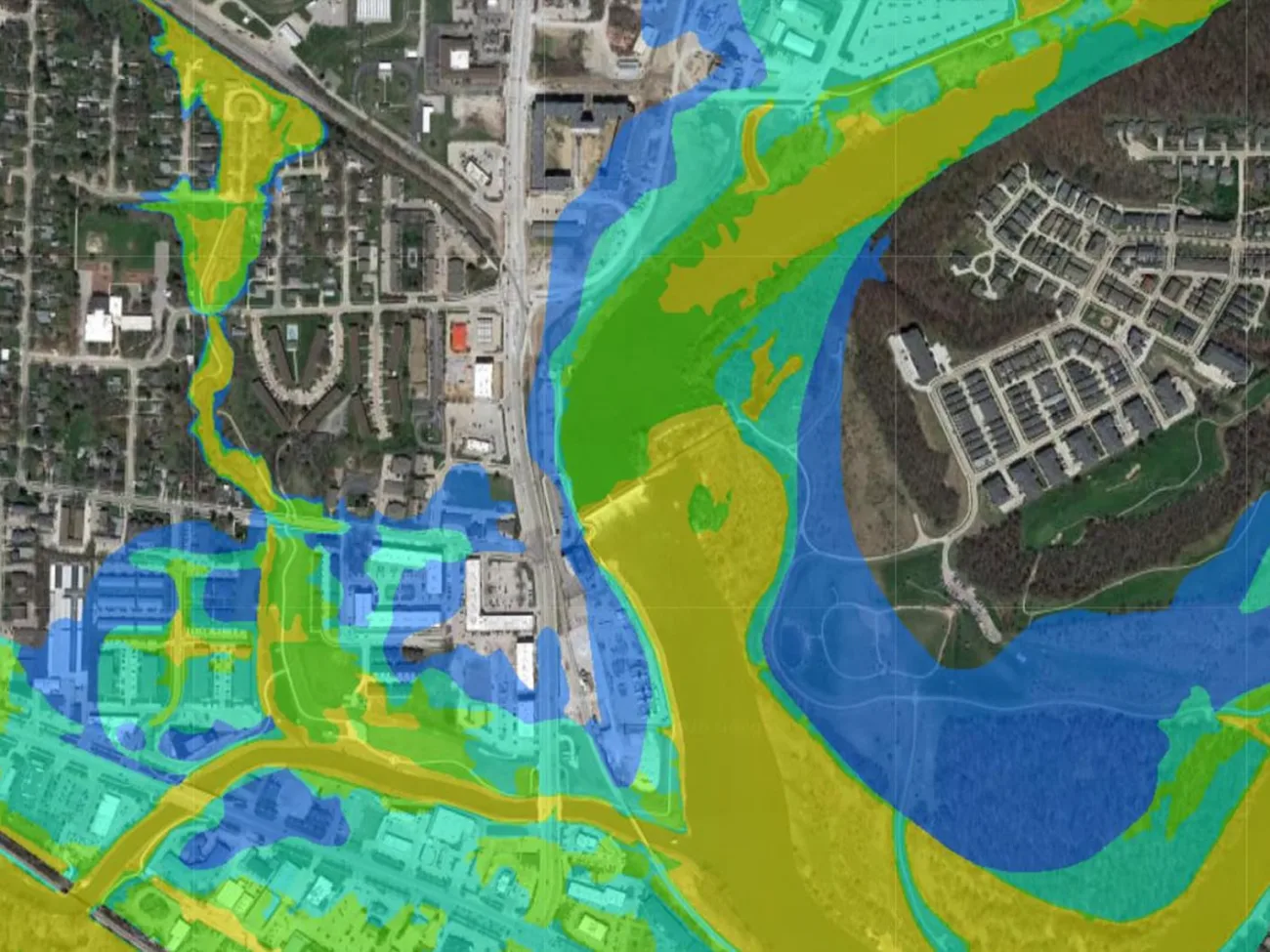
After heavy rainfall or a river overflow, imagery mapped against elevation data shows exactly which properties sat inside the flooded boundary, how long standing water and soil saturation likely persisted, and whether access roads were cut off, the details that determine both coverage and the size of a payout.
Wildfire impact assessment
Pre-fire imagery documents vegetation density and how close it sat to a structure, while post-fire imagery shows the burn scar, structural loss, and how far the fire actually reached. That combination lets an insurer separate a total loss from partial damage even while the area is still closed to entry.
Property alteration and dispute resolution
Occasionally a claim describes damage as tied to a recent event, but archival imagery shows the same condition present months earlier. Objective, time-stamped imagery settles that kind of dispute without turning it into a standoff between the claimant's account and the adjuster's judgment.
Large-scale catastrophe triage
When a hurricane or major flood generates tens of thousands of claims at once, comparing pre- and post-event imagery across an entire city lets a claims team sort properties by visible damage severity before a single inspector is dispatched, so the most severely affected policyholders get attention first instead of whoever happened to file earliest.
Operational and financial benefits for insurers
The case for moving claims evidence off the ground isn't just speed, it shows up directly in claims capacity, cost, and adjuster safety.
| Feature | Traditional claims assessment | Satellite-driven claims intelligence |
|---|---|---|
| Speed and turnaround | Weeks to months for site visits | Analysis-ready data delivered in under 24 hours to 7 days |
| Claims capacity | Limited by manual inspector availability | Up to 1.5x more claims processed per day remotely |
| Financial impact | High travel and labor expenses | Cuts loss adjustment expenses (LAE) by approximately 20% |
| Adjuster safety | High risk of falls, toxic exposure, or unstable structures | Contactless evaluation keeps adjusters safely in the office |
Real-world case examples

Derna, Libya: 24-hour flood extent mapping
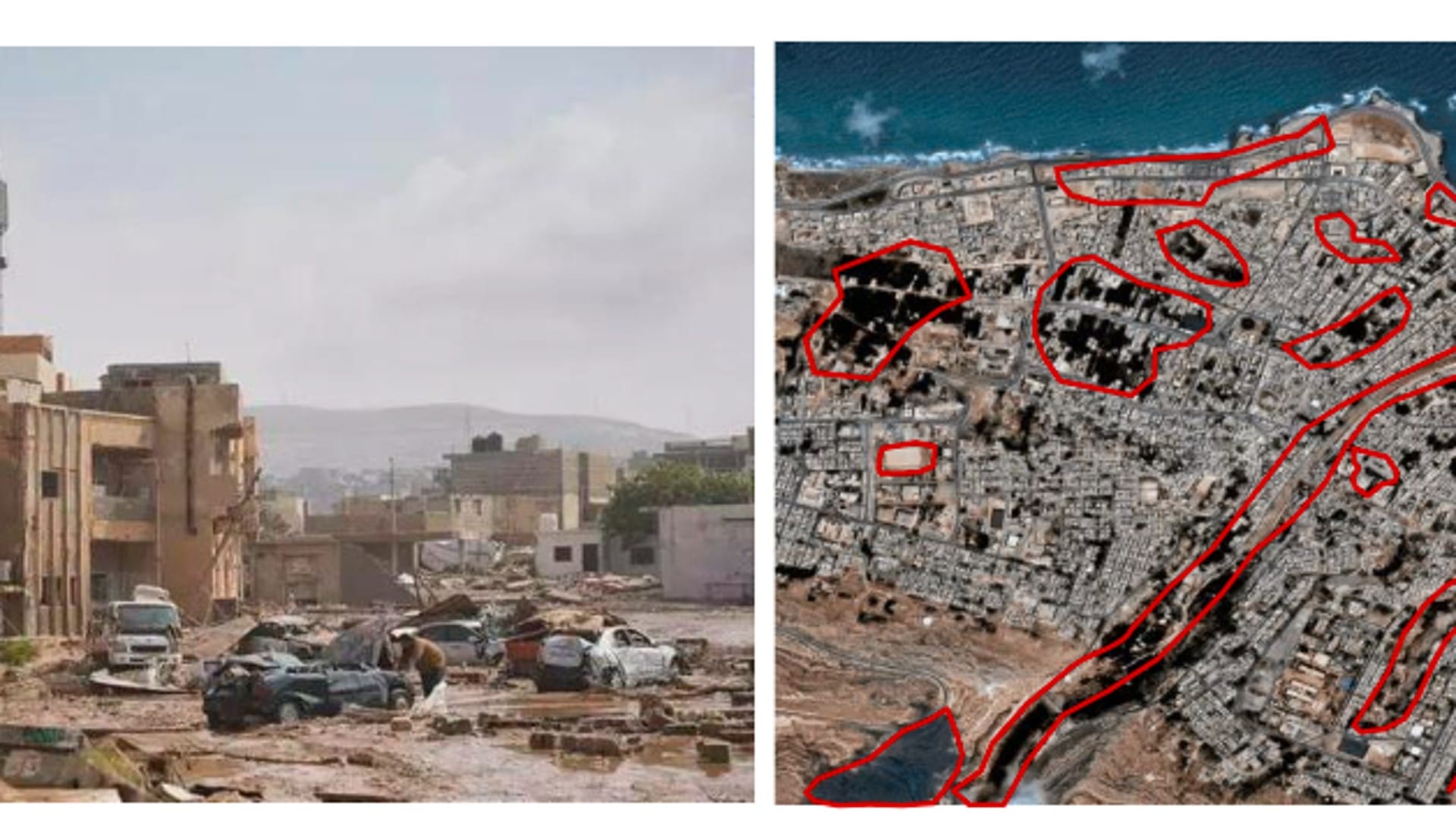
Just 24 hours after catastrophic flooding, high-resolution satellite imagery delivered precise waterline mapping and flood extent boundaries across the city. That turnaround enabled claims validation and disaster impact modeling to begin immediately, while traditional adjusters still had no way to physically reach the area.
India and Nigeria: crop loss and drought validation
Multi-source satellite remote sensing combined with local ground insight tracked crop health across affected regions to validate flood and drought impact, supporting accurate insurance claim payouts and government subsidy verification without a field visit to every affected farm. The same data sources work on the underwriting side too, before a policy is even written, covered in full in our guide to satellite data for crop risk underwriting in counties with incomplete yield records.
Key takeaways
- Satellite archives dating back to the late 1990s let insurers build an indisputable pre-loss baseline, settling whether damage happened during the policy window or existed beforehand.
- Sub-meter optical imagery (down to 30 cm) documents storm, flood, and wildfire damage across whole neighborhoods at once; SAR keeps that evidence flowing through cloud, smoke, and darkness.
- Objective, time-stamped imagery verifies property boundaries and unauthorized construction, reducing fraudulent or inflated claims without relying on a claimant's account alone.
- Satellite-driven claims intelligence cuts turnaround from weeks or months to under 24 hours to 7 days, raises claims capacity by up to 1.5x, and lowers loss adjustment expenses by roughly 20%.
- The same before-and-after method applies across perils, storm roofs, flood extent, wildfire burn scars, and large-scale catastrophe triage, just with different data read on top of the imagery.
Frequently asked questions
How is satellite imagery used as evidence in insurance claims?
Satellite imagery is used by comparing a pre-loss baseline image of a property against post-event imagery to verify whether damage occurred during the insured policy period, measure its extent, and confirm details like property boundaries or unauthorized construction. The comparison gives insurers objective, time-stamped evidence instead of relying solely on a claimant's account or a delayed site visit.
How far back do satellite imagery archives go for baseline verification?
Commercial satellite archives used for insurance baseline verification typically extend back to the late 1990s, giving insurers a long enough historical record to establish an indisputable pre-loss condition for most insured properties and assets.
Can satellite imagery help detect insurance fraud?
Yes. Unbiased satellite data can verify property lines, detect illegal construction or unauthorized additions, confirm how a building is actually being used, and check the details of an unverified claim against objective visual proof, which reduces fraudulent or exaggerated claims.
Does satellite-based claims evidence work through clouds, smoke, or at night?
Standard optical satellite imagery cannot see through cloud cover, heavy smoke, or darkness. Synthetic Aperture Radar (SAR) solves this by emitting its own microwave signal and reading ground conditions regardless of weather or time of day, making it the reliable option for evidence gathered during active storms or immediately after floodwaters crest.
How is satellite imagery used for crop and agricultural insurance claims?
Multi-spectral satellite imagery tracks soil moisture, vegetation health using indices like NDVI, and drought stress across a field or region. Insurers use these measurements to validate crop loss, yield reduction, and weather-related agricultural damage without sending an inspector to scout every affected field manually.
How much faster is satellite-based claims assessment compared to a manual site visit?
A manual site visit can take weeks to months to schedule and complete, especially after a major disaster. Satellite-driven claims intelligence typically delivers analysis-ready data in under 24 hours to 7 days, and can let insurers process up to 1.5 times more claims per day since assessment doesn't depend on inspector availability.
Can satellite imagery resolve disputes about when property damage actually occurred?
Yes. Comparing archival satellite imagery against the timeline of a claimed event can show whether reported damage was already present before the event in question, giving insurers an objective, time-stamped basis for resolving disputes over when damage actually happened.
What satellite resolution do insurers need for claims verification?
Sub-meter optical resolution, down to around 30 cm, is standard for documenting visible structural damage such as roof loss or building destruction across a claims area. Crop and agricultural claims can rely on coarser multi-spectral resolution, since the relevant signal is vegetation health and moisture rather than fine structural detail.
Sources and further reading
- Commercial Earth observation archive providers: historical optical imagery coverage dating back to the late 1990s
- China Siwei: GF-3 SAR and LT-1 InSAR specifications for all-weather, day-and-night claims evidence
- XRTech Group: Derna, Libya flood response and 24-hour flood extent mapping case study
- XRTech Group: agricultural insurance validation case studies, India and Nigeria
Need satellite evidence for an active claim?
Task optical or SAR imagery over an insured property or an affected region and get back time-stamped before-and-after evidence, ready for claims review in GeoTIFF, SHP, or a shareable report.


