What NASA's Real Satellite Photo of India on Diwali Actually Shows
On this page
- The real NASA photo of India on Diwali
- The viral "India lit up for Diwali" photo is not real
- Why Diwali's extra light is hard for a satellite to see
- What satellites actually track about India's night lights
- How to actually see India from space yourself
- Frequently asked questions
- Sources and further reading
A practical guide to what satellite images actually show of India on Diwali, the real NASA photo behind the story, why it was taken the night before Diwali and not during it, the colorful viral image that is often shared as proof but isn't, and whether Diwali's extra light is something a satellite can even detect.
Quick answer
Yes, NASA has a real satellite photo of India from space taken the night before Diwali, captured November 12, 2012 by the VIIRS instrument on the Suomi NPP satellite, one day ahead of Diwali 2012 on November 13. It shows India's ordinary nighttime city lights, not a special Diwali brightening effect, and NASA itself says any extra light the festival produces is likely too subtle to see from orbit. The colorful, dramatic image most often shared online as "India lit up for Diwali" is not this NASA photo at all, it's a repurposed 2003 population-growth map with nothing to do with the festival.
The real NASA photo of India on Diwali
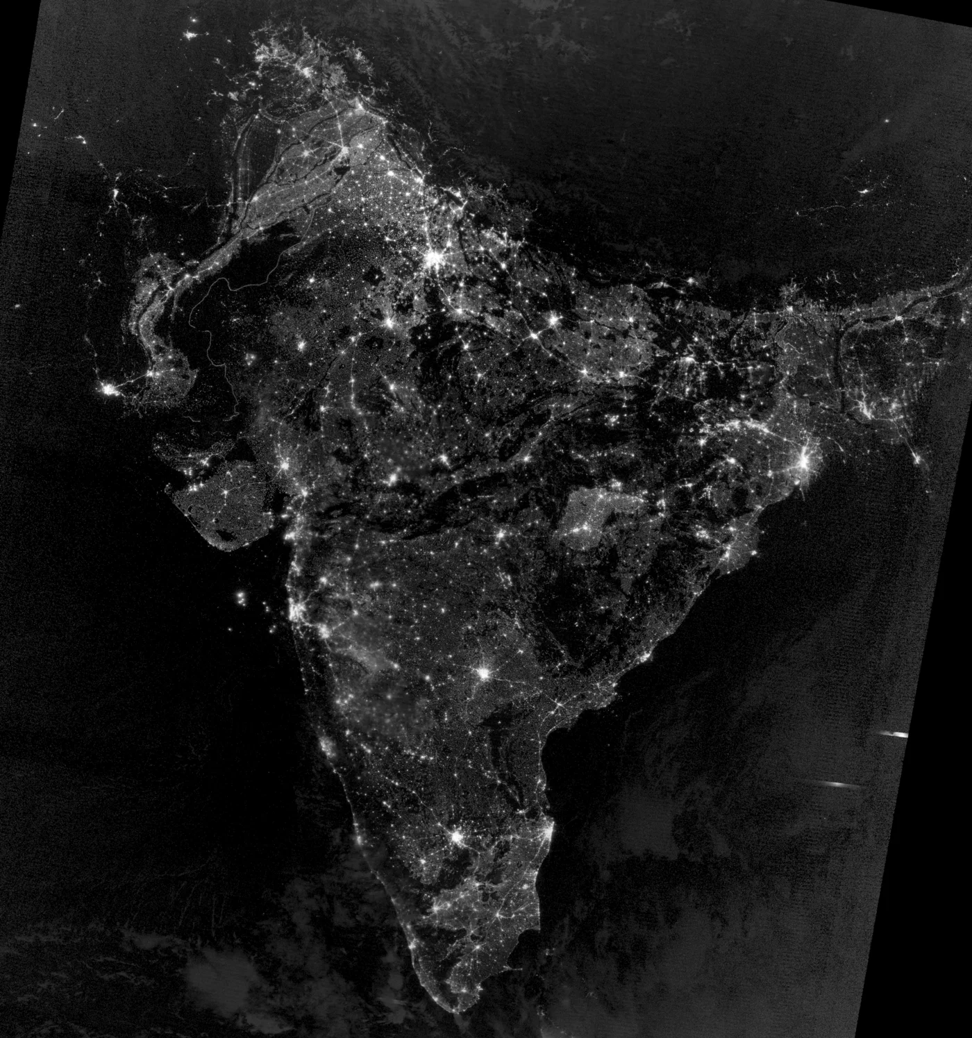
Every year around the festival, searches for "India on Diwali from space," "India Diwali from space," and similar phrases spike, almost always chasing the same viral image covered further down this page. There is a real one. On November 12, 2012, the VIIRS Day/Night Band instrument on NASA and NOAA's Suomi NPP satellite captured a nighttime image of South Asia, published by NASA Earth Observatory as "South Asian Night Lights," credited to Jesse Allen and Robert Simmon. The timing lines up almost exactly with Diwali that year, which fell on November 13, 2012, one day after the image was taken. The Day/Night Band is built to pick up extremely faint light sources, from city grids and highway networks down to a single fishing boat's deck lights, which is why the Indo-Gangetic Plain across northern India and Pakistan shows up as one of the most densely lit regions on the planet.
What the image actually shows is India's permanent electrical grid, the same dense, branching pattern of cities, towns, and highways that would appear on any clear night of the year. It is a genuine satellite photograph of India from space around Diwali, not a photograph of Diwali itself.
The viral "India lit up for Diwali" photo is not real
A completely different image is the one most people have actually seen, a vivid, color-coded map of India that circulates every year around Diwali with captions claiming it shows the country glowing for the festival. NASA Earth Observatory addresses this directly, and traces the image to a 2003 composite built by NOAA scientist Chris Elvidge from the older DMSP Operational Linescan System, not VIIRS, and not Diwali.
That 2003 composite was never about a single night at all, it was built to show population growth over roughly a decade. Its colors are a timeline, not a brightness map, white areas mark city lights that were already visible before 1992, while blue, green, and red mark lights that first appeared in 1992, 1998, and 2003 respectively. Shared out of context with a Diwali caption, those warm reds and greens read as festive illumination, which is exactly why the image keeps going viral every year, even though it predates VIIRS, predates Suomi NPP, and has no connection to any festival.
Why Diwali's extra light is hard for a satellite to see
NASA's own assessment is blunt on this point, calling any additional light from Diwali celebrations "likely imperceptible when observed from space." The reason comes down to scale. A VIIRS Day/Night Band pixel over a dense Indian city already integrates light from permanent streetlighting, vehicle headlights, shopfronts, and millions of individual households, a baseline that doesn't go dark the rest of the year either. Diwali adds diyas, string lights, and fireworks on top of that baseline for a few hours, a real but comparatively small increase against light sources that are already saturating the sensor in most urban pixels.
That asymmetry is also exactly why the wrong viral image took hold so easily, a map built around deliberate, high-contrast colors coded to a decade of growth looks far more dramatic than the genuine, subtle difference a single festival night actually produces in raw VIIRS data.
Want a current satellite image of an Indian city, not an archive photo from 2012?
Search free archive imagery or task a fresh high-resolution capture of any site in India, with an instant price estimate.
What satellites actually track about India's night lights
Night-lights data is a genuine, widely used tool, just not for catching a single festival. Researchers use years of VIIRS Day/Night Band data to track urbanization, electrification, and economic activity, change too gradual to see night to night but unmistakable across a decade. A 2026 analysis of VIIRS data from 2014 to 2022 found global nighttime lighting increasing by roughly 2 percent a year, a 16 percent rise worldwide over that period, with China and northern India among the regions growing brightest as cities expanded and new areas connected to the grid.
| Reliably visible | Not reliably visible |
|---|---|
| A city or region's permanent light footprint | One festival's extra lighting on a single night |
| Multi-year urban growth and new electrification | Night-to-night changes within a normal range |
| Power outages and conflict-related blackouts | Fireworks, which are brief and often cloud- or smoke-obscured |
This is the same Day/Night Band sensor, flying on the same Suomi NPP satellite, that produced the real 2012 India image above, just pointed at a different question, growth over years rather than one night's celebration.
How to actually see India from space yourself
NASA's own near-real-time viewer is the easiest way to look at this kind of imagery directly rather than relying on a screenshot that's been recaptioned for a holiday. NASA Worldview lets anyone browse recent VIIRS and MODIS imagery of India, day or night bands included, usually within a few hours of capture, for free, with no account needed. It won't show you a single night brightening for Diwali for the same sensitivity reasons covered above, but it will show you the real, current version of the same kind of image NASA published in 2012.
For a sharp, current, building-level view of one specific place in India rather than a country-wide night-lights composite, that requires commercial satellite imagery, the free sources covered elsewhere on this site top out at 10 to 30 meter resolution, enough to see a city's shape but not a single structure.
Key takeaways
- NASA's real satellite photo of India around Diwali was captured November 12, 2012 by VIIRS on Suomi NPP, the night before Diwali 2012 on November 13.
- That image shows India's ordinary, permanent nighttime lighting, not a special Diwali effect, NASA states any extra light from the festival is likely imperceptible from orbit.
- The colorful image widely shared as "India lit up for Diwali" is a 2003 DMSP population-growth composite by NOAA's Chris Elvidge, unrelated to Diwali or to VIIRS.
- Night-lights data genuinely tracks India's urban growth, global VIIRS data from 2014 to 2022 shows roughly 2 percent brighter lighting worldwide per year, with India among the fastest-growing regions.
- NASA Worldview is a free way to view real, current VIIRS imagery of India; a specific building-level view of one site requires commercial satellite imagery.
Frequently asked questions
Is there a real NASA satellite photo of India on Diwali?
Yes. NASA Earth Observatory published a real VIIRS Day/Night Band image of India and South Asia at night, captured November 12, 2012, the night before Diwali 2012 on November 13. It shows ordinary city lighting, not a special Diwali brightening effect.
What does India from space look like on Diwali?
Much like it looks any other clear night, a dense, branching web of city and highway lights, brightest across the Indo-Gangetic Plain in northern India. NASA's own imagery shows no visible festival-specific brightening, since Diwali's extra light is small relative to a city's existing nighttime baseline.
Is the famous colorful India Diwali satellite photo real?
The image itself is real data, but it is not a Diwali photo. It is a 2003 composite built from older DMSP satellite data by NOAA scientist Chris Elvidge to show population growth over roughly a decade, with colors marking when city lights first appeared, not how bright a single night was.
Can satellites actually see Diwali lights from space?
Not reliably. NASA states that any extra light produced by Diwali celebrations is likely imperceptible when observed from space, since it adds only a small increase on top of a city's already-bright year-round electrical grid lighting.
Why can't satellites detect Diwali's extra light?
Satellite night-lights sensors like VIIRS already pick up a city's full baseline lighting, streetlights, vehicles, shopfronts, and homes, which is bright and widespread. Diwali adds lamps and fireworks for a few hours on top of that baseline, a real but comparatively small increase that is hard to isolate pixel by pixel.
Is India's night lighting actually increasing over time?
Yes, but from urban growth, not festivals. An analysis of global VIIRS data from 2014 to 2022 found nighttime lighting increasing by roughly 2 percent a year worldwide, about 16 percent total, with China and northern India among the fastest-growing regions as cities expanded and new areas were electrified.
How can I see a real satellite image of India myself?
NASA Worldview is a free tool showing near-real-time VIIRS and MODIS imagery of India, usually within a few hours of capture, including the same Day/Night Band used for night-lights imagery. For sharp, building-level detail of one specific site, commercial satellite imagery is required.
Sources and further reading
- NASA Earth Observatory: South Asian Night Lights, image and caption by Jesse Allen and Robert Simmon, VIIRS Day/Night Band data, November 12, 2012
- NASA Earth Observatory: clarification of the 2003 DMSP population-growth composite by NOAA's Chris Elvidge, commonly misattributed as a Diwali image
- Diwali 2012 festival date, November 13, 2012
- Global VIIRS Day/Night Band nighttime lighting trend analysis, 2014 to 2022
- NASA Worldview, near-real-time VIIRS and MODIS imagery viewer
For more on how current satellite imagery really is, see our guide to whether satellite images are real time, and for a full list of free imagery tools, see free satellite imagery sources.
Need a real, current satellite image of a site in India?
Search free archive imagery or task a fresh high-resolution capture, with an instant price estimate before you order.