
Building 3D Models From Satellite Stereo Imagery
On this page
- What building 3D models from satellite stereo imagery actually involves
- Key satellites for stereo and tri-stereo acquisition
- Technical workflow: from stereo image pairs to 3D models
- 01. Stereo image pair acquisition
- 02. AI-based feature and contour extraction
- 03. Contour regularization
- 04. Adhesion segmentation
- 05. Homonymous contour pairing and elevation correction
- 06. 3D model generation
- Primary 3D model deliverables
- Where these 3D models actually get used
- Pricing and data compatibility
- Frequently asked questions
- Sources and further reading
Building 3D models from satellite stereo imagery starts with something deceptively simple: two pictures of the same rooftop, taken from two different points in orbit. Everything downstream of that, the elevation grid, the building height, the box-model city block that eventually lands inside a digital twin, gets calculated from the tiny geometric difference between those two views.
Quick answer
3D models from satellite imagery are built by capturing two or more images of the same location from different orbital angles, stereo pairs or tri-stereo triplets, and processing them through photogrammetry and AI-based computer vision. Dedicated satellites like GF-7 and ZY-3 capture native stereo or tri-stereo geometry in a single pass, while agile platforms such as SuperView-2 and SuperView Neo-1 are tasked for stereo collection on demand. The resulting depth data produces Digital Elevation Models (DEM), Digital Surface Models (DSM), simplified 3D Building White Models, and full 3D Digital Twins, delivered in GIS, CAD, or 3D-rendering formats such as GeoTIFF, DWG, OBJ, or 3D Tiles.
What building 3D models from satellite stereo imagery actually involves
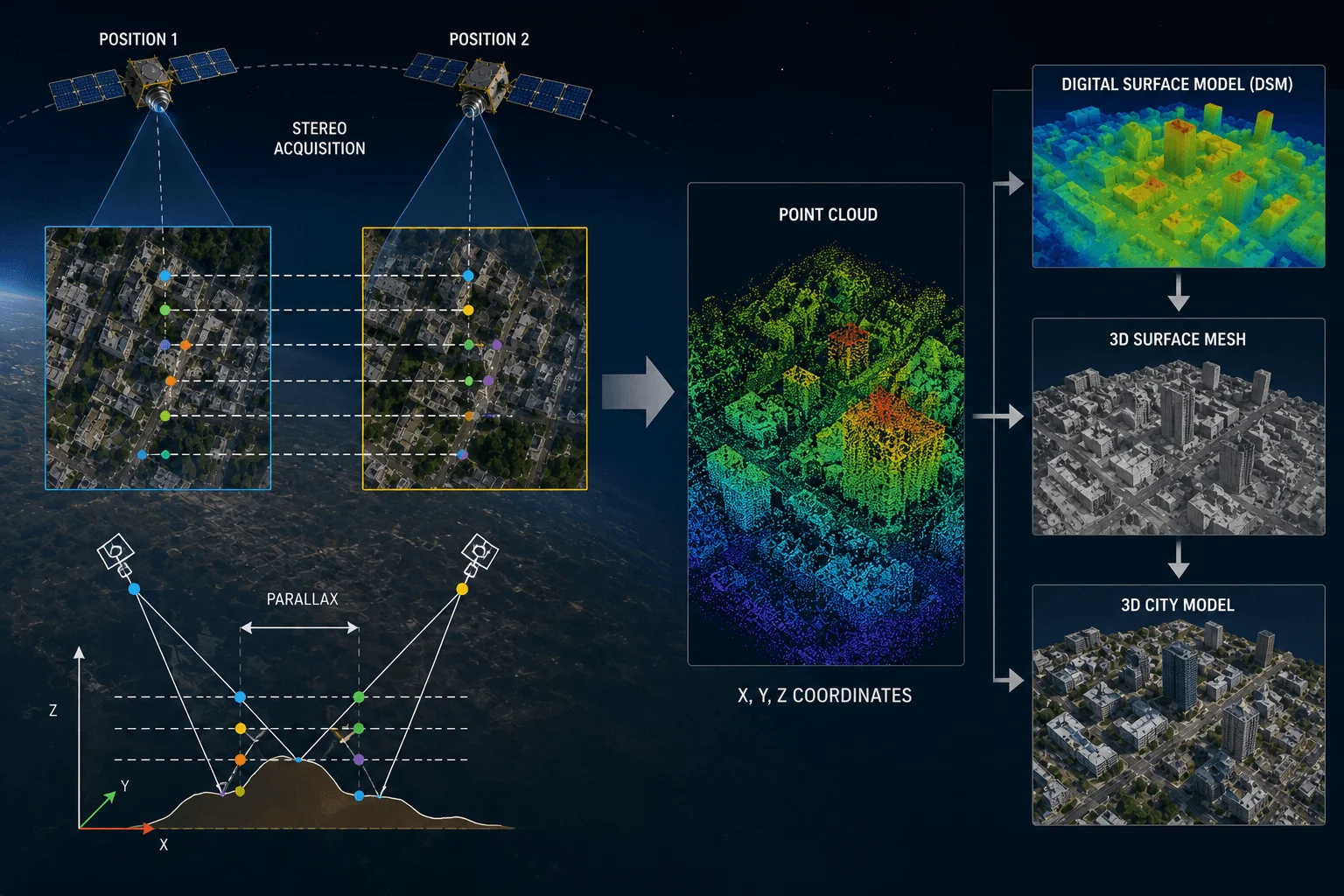
The underlying method is photogrammetry: capture the same ground location from two or more orbital angles, measure how far a given rooftop, ridge, or road edge shifts between the two views (its parallax), and use that shift to calculate height. Two images from two angles is a stereo pair. Three images, typically forward, nadir, and backward looking, is a tri-stereo triplet, which adds redundancy and improves accuracy in tall, shadow-heavy urban scenes. Either way, this depth-sensing approach is what turns a flat optical image into height-aware 3D data, the foundation for DEMs, DSMs, building white models, and full 3D digital twins used across urban planning, construction monitoring, and disaster management.
Key satellites for stereo and tri-stereo acquisition
Not every optical satellite can do this. Building usable 3D data takes a sensor that's either purpose-built for stereo geometry or agile enough to be re-tasked for it on the same pass.
GF-7 is China's first sub-meter dedicated stereo mapping satellite. Its dual-linear CCD camera looks forward at +26° and backward at -5° on the same orbital pass, so every scene comes back as a native stereo pair without any special tasking. A two-beam laser altimeter rides alongside it, pushing vertical accuracy to ≤0.5 m RMS on flat terrain, precise enough for 1:10,000 scale mapping.
ZY-3 (01/02/03) takes a different approach: a civilian stereomapping constellation built around a three-camera array, forward, backward, and nadir, shooting at 2.1 m nadir resolution. Rather than one-off tasking, the constellation is used to continuously build and update a 1:50,000 global DEM database.

SuperView-2 (GFDM) is an agile 0.42 m satellite that gets tasked for stereo work rather than capturing it by default. It can shoot a stereo pair at a 30° or 47° viewing angle, or a full tri-stereo triplet at 47° across an 80 km swath, making it a strong fit for dense urban canyons and high-rise districts where a single viewing angle would leave tall buildings occluded by their own shadows.
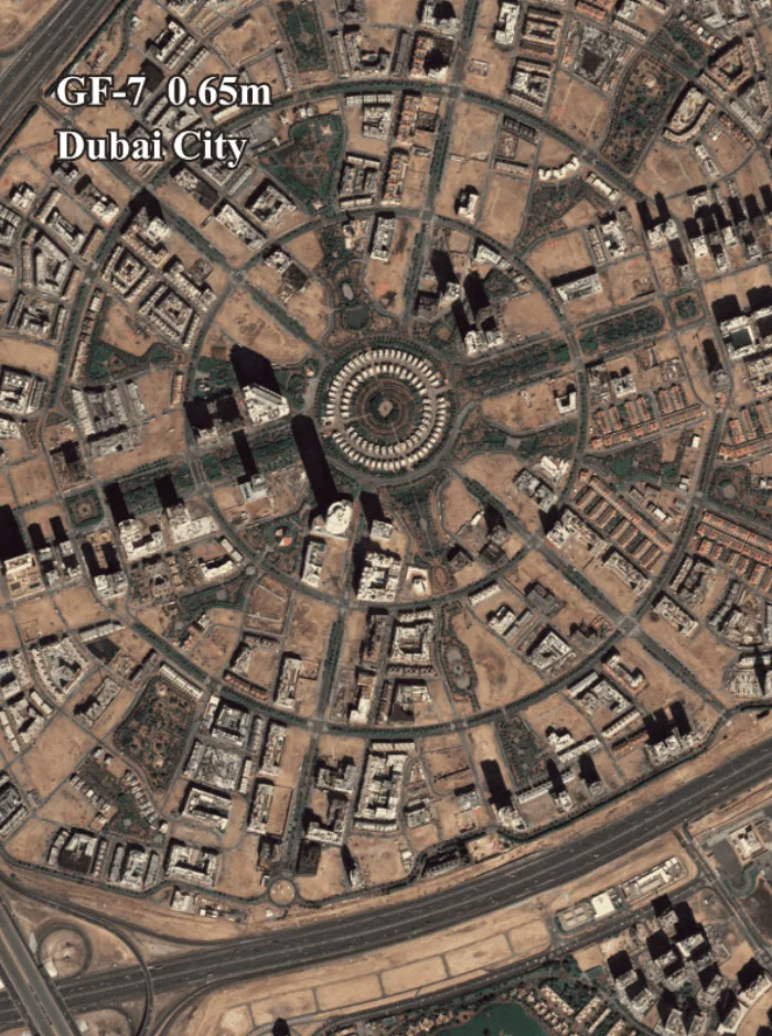
Beijing-3A, SuperView-1, and SuperView Neo-1 round out the options: high-agility optical constellations that aren't dedicated stereo satellites but can be tasked for sub-meter stereo collection across large areas, useful when a project needs city-wide 3D terrain and urban modeling rather than a single dense site.
| Satellite / constellation | Resolution | Stereo geometry | Best suited for |
|---|---|---|---|
| GF-7 | 0.65 m PAN, dual-linear CCD | Native stereo every pass (+26° / -5°) plus laser altimeter | Sub-meter DEMs, ≤0.5 m RMS vertical accuracy, 1:10,000 scale mapping |
| ZY-3 (01/02/03) | 2.1 m nadir | Native tri-stereo every pass (forward, nadir, backward) | Continuous 1:50,000 global DEM database production |
| SuperView-2 (GFDM) | 0.42 m | Tasked stereo (30°/47°) or tri-stereo (47°, 80 km swath) | Dense urban canyons and high-rise modeling |
| Beijing-3A / SuperView-1 / SuperView Neo-1 | Sub-meter | Tasked stereo pairs | Large-scale, city-wide 3D terrain and urban modeling |
Technical workflow: from stereo image pairs to 3D models
Turning a stereo pair into a usable 3D model runs through an automated photogrammetric and AI pipeline, not a manual trace.
01. Stereo image pair acquisition
The satellite captures left and right views (stereo) or forward, nadir, and backward views (tri-stereo) of the same location during a single orbital pass, giving the pipeline the overlapping geometry it needs to measure depth.
02. AI-based feature and contour extraction
Deep learning models scan the optical imagery and automatically pull out building footprints and roof top contours, the same extraction step used in automated change detection and mapping pipelines.
03. Contour regularization
Raw extracted edges get cleaned up through principal-direction adjustment, redundant point simplification, and sharp-angle elimination, so a building's outline matches its actual geometric shape instead of a jagged pixel boundary.
04. Adhesion segmentation
Buildings sitting close together get separated so they aren't extracted as a single blob: height-difference segmentation splits structures of different heights, and common-edge construction splits handle adjacent buildings of similar height.
05. Homonymous contour pairing and elevation correction
The algorithm matches corresponding contours between the left and right stereo views and adjusts each polygon pair for maximum overlap. That overlap identifies the building's true top elevation, and subtracting the ground elevation underneath it gives an exact building height, no ground survey required.
06. 3D model generation
The regularized vector geometry and the calculated height data assemble into the final 3D model, ready to export as a DEM, DSM, building white model, or textured city model depending on what the project needs.
Primary 3D model deliverables
The same stereo pipeline feeds four related but distinct output products, and knowing which one a project actually needs is most of the battle.
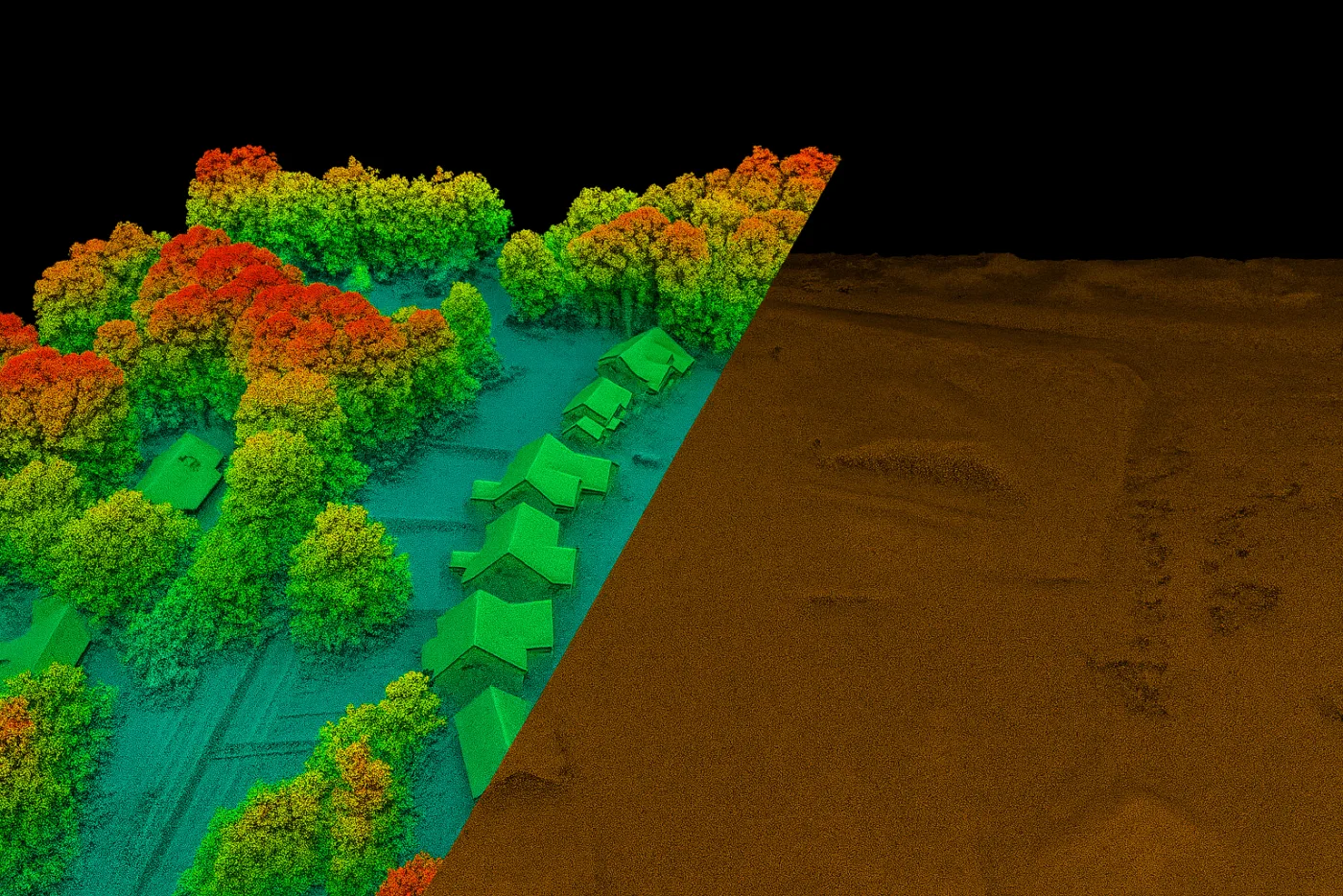
Digital Elevation Models (DEM) represent the bare-earth ground surface with buildings and vegetation stripped out, while Digital Surface Models (DSM) keep every surface feature standing, rooftops, bridges, canopy trees included. Both are typically delivered at 2 to 10 meter grid spacing with ±3 m vertical RMSE accuracy.
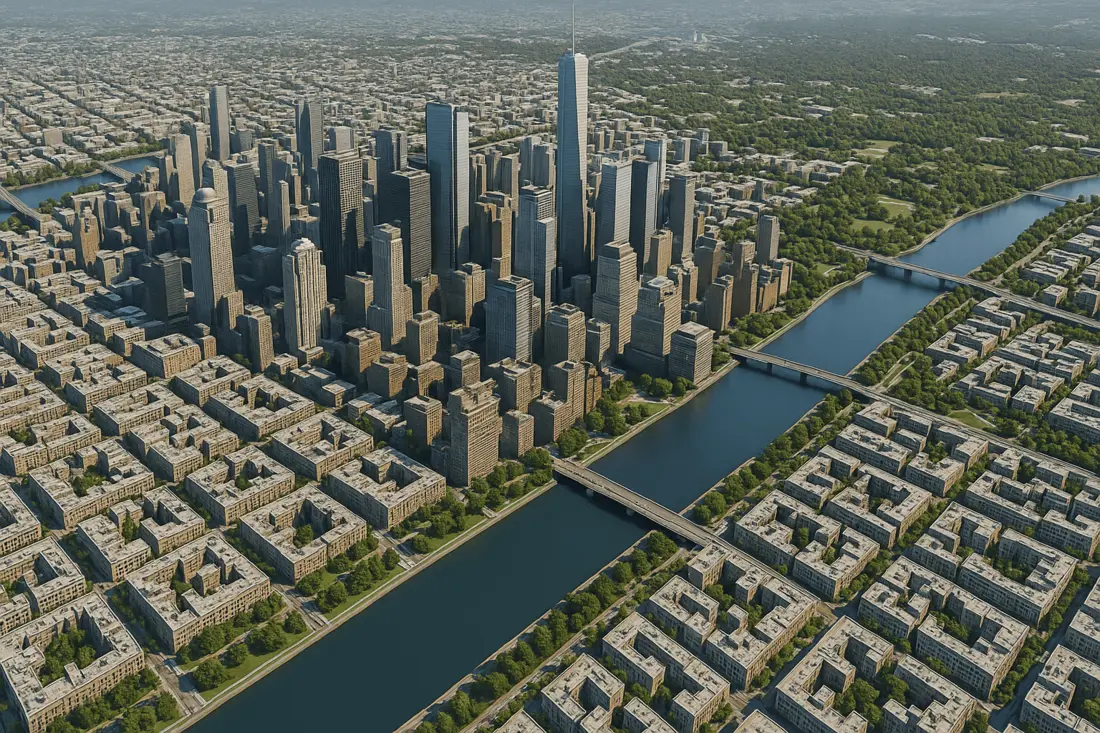
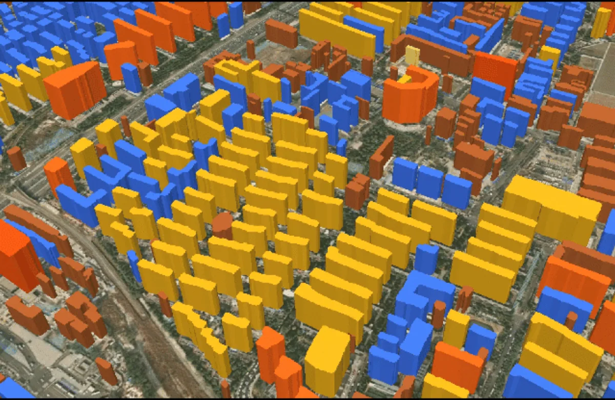
Building White Models are the simplified, untextured 3D "box models" that come directly out of the contour and height data: no facades, no rooftop detail, just the exact footprint, height, and 3D shape of each structure. That simplicity is the point, they serve as standard base data for large-scale city displays, urban planning, housing administration, and disaster assessment without the rendering overhead heavy textures would add.
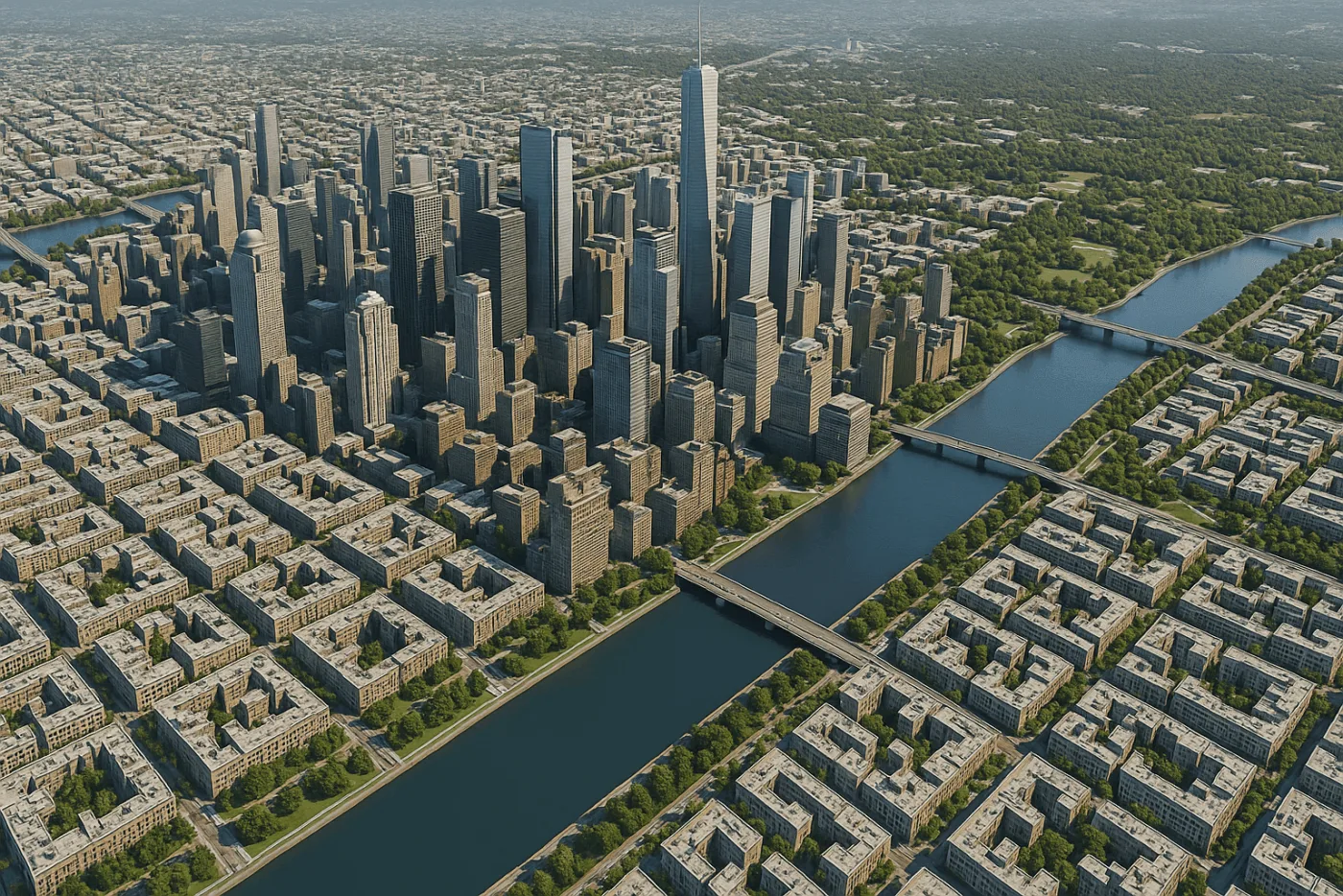
3D City Models and Digital Twins sit at the top of the stack: high-resolution digital replicas that combine 3D terrain, building contours, and real-world rendering into one scene. Layered with IoT feeds, spatial big data, and GIS data, they become the operating picture behind smart park management, airport operations, flood simulations, and urban growth monitoring.
| Deliverable | What it represents | Typically used for |
|---|---|---|
| DEM | Bare-earth ground surface, 2–10 m spacing, ±3 m RMSE | Hydrology, terrain analysis, flood modeling |
| DSM | Full surface including buildings, bridges, canopy | Urban drainage analysis, line-of-sight studies, canopy assessment |
| Building white model | Untextured 3D box model per building, footprint plus height | City-wide displays, urban planning, housing administration, disaster assessment |
| 3D city model / digital twin | Fully rendered replica combining terrain, buildings, and live data layers | Smart park management, airport operations, flood simulation, growth monitoring |
Where these 3D models actually get used
Once a stereo-derived model exists, it tends to get reused across several teams rather than sitting inside a single department's GIS folder.
- Urban planning: building white models and DSMs give planning departments an up-to-date, city-wide base layer for zoning review and scheme comparison without commissioning a new aerial survey each time.
- Construction and infrastructure monitoring: stereo-derived height data tracks a build's progress against its planned massing, and repeat acquisitions catch deviations early.
- Disaster management and flood risk planning: a bare-earth DEM combined with a DSM exposes exactly where buildings and terrain will block or channel floodwater, letting planners model inundation before a storm arrives rather than after.
- Smart park and airport operations: a 3D digital twin layered with IoT sensor feeds gives operations teams one live view of a site instead of separate CAD drawings, sensor dashboards, and satellite images.
- Urban growth monitoring: comparing white models generated from repeat stereo tasking over time shows exactly which blocks changed, and by how much, without re-surveying the whole city.
Pricing and data compatibility
Stereo and tri-stereo tasking cost more than a standard mono capture, for a straightforward reason: the satellite has to shoot the same scene from multiple angles instead of one.
Standard cost multiplier for stereo (two-angle) satellite imagery collection.
Standard cost multiplier for tri-stereo (three-angle) satellite imagery collection.
Deliverables are exported in formats that plug directly into whatever software a team already runs, no intermediate conversion step required.
| Ecosystem | Formats |
|---|---|
| GIS | GeoTIFF, SHP |
| CAD / engineering | DWG, IFC |
| 3D rendering and visualization | OBJ, OSGB, 3D Tiles, i3S, S3M, FBX |
Key takeaways
- 3D models are built from two or more satellite images of the same location taken at different orbital angles, stereo pairs or tri-stereo triplets, processed through photogrammetry and AI.
- GF-7 and ZY-3 capture native stereo or tri-stereo geometry on every pass; SuperView-2, Beijing-3A, SuperView-1, and SuperView Neo-1 get tasked for stereo collection on demand.
- The workflow runs through AI contour extraction, contour regularization, adhesion segmentation, and homonymous contour pairing before assembling the final 3D model.
- The same pipeline produces four distinct deliverables: bare-earth DEMs, full-surface DSMs, untextured building white models, and fully rendered 3D digital twins.
- Stereo imagery is priced at 2× the standard mono cost, and tri-stereo at 3×, with deliverables available in GeoTIFF, SHP, DWG, OBJ, OSGB, 3D Tiles, i3S, S3M, FBX, and IFC.
Frequently asked questions
How are 3D models built from satellite stereo imagery?
3D models are built by capturing two or more satellite images of the same location from different orbital angles, then using photogrammetry and AI-based computer vision to measure the parallax between them. That depth data is used to extract building footprints, calculate elevation and building height, and assemble a finished 3D model, DEM, DSM, building white model, or digital twin.
What is the difference between stereo and tri-stereo satellite imagery?
Stereo imagery uses two images of the same location captured from two different angles, typically forward and backward looking. Tri-stereo adds a third, nadir (straight-down) image, giving three viewing angles instead of two. The extra angle improves accuracy in tall, shadow-heavy urban scenes where a single stereo pair might leave part of a building occluded.
Which satellites are used for stereo or tri-stereo 3D mapping?
GF-7 and the ZY-3 constellation (01/02/03) capture native stereo or tri-stereo geometry on every orbital pass. Agile satellites such as SuperView-2, Beijing-3A, SuperView-1, and SuperView Neo-1 aren't dedicated stereo sensors but can be tasked to collect stereo pairs or tri-stereo triplets on demand.
What is a building white model?
A building white model is a simplified, untextured 3D box model that reflects a building's exact footprint, height, and basic 3D shape, generated directly from stereo-extracted contours and elevation data. It serves as standard base data for city-wide displays, urban planning, housing administration, and disaster assessment without the processing overhead of a fully textured model.
What is the difference between a DEM and a DSM?
A Digital Elevation Model (DEM) represents the bare-earth ground surface with buildings and vegetation removed. A Digital Surface Model (DSM) keeps every surface feature in place, including rooftops, bridges, and tree canopy. Both are commonly delivered at 2 to 10 meter grid spacing with roughly ±3 meter vertical RMSE accuracy.
How much more expensive is stereo or tri-stereo satellite imagery than standard imagery?
Stereo satellite imagery is typically priced at twice the cost of standard mono imagery, and tri-stereo imagery at three times the mono cost, reflecting the additional orbital passes or viewing angles needed to capture the extra images.
What file formats do 3D satellite-derived models come in?
3D model deliverables are typically provided in GeoTIFF and SHP for GIS software, DWG and IFC for CAD and engineering workflows, and OBJ, OSGB, 3D Tiles, i3S, S3M, or FBX for 3D rendering and visualization platforms, chosen to match whatever software a project already uses.
Can stereo-derived 3D models be used outside of urban planning?
Yes. Beyond urban planning, the same stereo-derived DEMs, DSMs, and 3D city models support construction and infrastructure progress monitoring, disaster management and flood risk simulation, smart park and airport operations through digital twins integrated with IoT sensors, and ongoing urban growth monitoring through repeat tasking.
Sources and further reading
- China Siwei and CRESDA: GF-7 dual-linear CCD stereo camera and laser altimeter specifications
- CNSA and CRESDA: ZY-3 (01/02/03) three-line array stereomapping and global DEM production specifications
- China Siwei: SuperView-2 (GFDM), Beijing-3A, SuperView-1, and SuperView Neo-1 agile tasking specifications
- XRTech Group: 3D model deliverable formats, stereo and tri-stereo pricing schedule, 2026
Need a DEM, DSM, or 3D model for your site?
Task stereo or tri-stereo satellite imagery over your area of interest and get back a DEM, DSM, building white model, or full 3D digital twin in the GIS, CAD, or rendering format your team already uses.


